चित्र:RomanEmpire 117.svg

Size of this PNG preview of this SVG file: ५१२ × ३७६ पिक्सेल. इतर resolutions: ३२० × २३५ पिक्सेल | ६४० × ४७० पिक्सेल | १,०२४ × ७५२ पिक्सेल | १,२८० × ९४० पिक्सेल | २,५६० × १,८८० पिक्सेल.
मूळ संचिका (SVG संचिका, साधारणपणे ५१२ × ३७६ pixels, संचिकेचा आकार: ७०४ कि.बा.)
सारांश
| वर्णन |
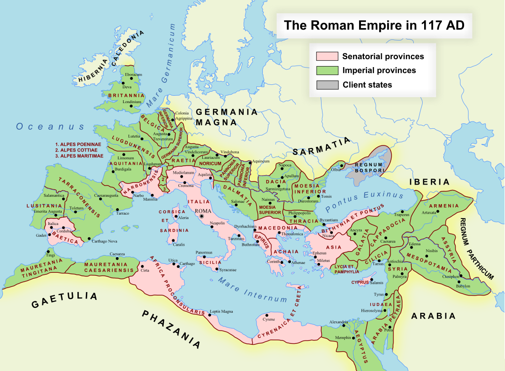
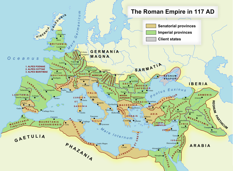
English: The maximum extent of the Roman Empire. Superimposed on a physical map. Senatorial Provinces Imperial Provinces Client States Español: Máxima extensión del Imperio Romano. Superpuesto en un mapa físico. Provincias Senatoriales Provincias Imperiales Estados satélite Deutsch: Das Römische Reich zur Zeit seiner maximalen Ausdehnung unter Trajan, 117 n. Chr. Senatorische Provinz Kaiserliche Provinz Klientelkönigtum Latina: Extentum maximum de Imperium Romanum. Provinciae senatus Provinciae Imperii Civitates Clientes 中文:公元117年图拉真在位时期罗马帝国的最大疆域。 元老院行省 元首行省 附庸国 日本語: ローマ帝国の最大版図。(西暦117年、皇帝トラヤヌス) 元老院属州 皇帝属州 従属国 |
| दिनांक | ऑक्टोबर १७, इ.स. २००५ (first version); डिसेंबर १९, इ.स. २००७ (last version) |
| स्रोत | ने en.wikipedia पासून कॉमन्सवर हस्तांतरित केले. |
| लेखक | ArdadN at इंग्रजी विकिपीडिया |
| परवानगी (या संचिकेचा पुनर्वापर करीत आहे) |
Public Domain |
| इतर आवृत्तींस |
[]
|
| SVG genesis |


SVG Support
This document is in the Scalable Vector Graphic format (SVG) and requires a supported browser (Firefox, Google Chrome, Opera) or a SVG plugin for Internet Explorer and other browsers. SVG is an open, text-based format, which means this map can be downloaded and modified/translated completely using a vector graphics editor like Adobe Illustrator or Inkscape (free) or a text editor such as Notepad.
| BLANK THUMBNAIL | View large PNG | View medium PNG | SVG Plugin for Internet Explorer and other browsers |
|---|---|---|---|
| Click here (purge cache) and then CTRL+F5 to reload. Help? | Try 1 Try 2 | Try 1 Try 2 | Adobe SVG plugin |
| Recommended browser | More Help | ||
| Firefox | List of SVG tools |
परवाना:
ArdadN at इंग्रजी विकिपीडिया, the copyright holder of this work, hereby publishes it under the following license:
| I, the copyright holder of this work, release this work into the public domain. This applies worldwide. असे करणे काही देशांमधे कायद्यानुसार शक्य नसू शकते. असे असल्यास : मी कोणालाही कोणत्याही कारणासाठी हे काम वापरण्याचे अधिकार कोणत्याही बंधनाशिवाय जर अशी बंधने कायद्याने बंधनकारक नसतीलतर देत आहोत. |
संचिकेचा इतिहास
संचिकेची त्यावेळची आवृत्ती बघण्यासाठी त्या दिनांक/वेळेवर टिचकी द्या.
| दिनांक/वेळ | छोटे चित्र | आकार | सदस्य | प्रतिक्रीया | |
|---|---|---|---|---|---|
| सद्य | १७:१८, २४ नोव्हेंबर २०२२ | | ५१२ × ३७६ (७०४ कि.बा.) | Vikarna | alpes poeniae → alpes poeninae |
| ०८:०६, २ सप्टेंबर २०२१ |  | ५१२ × ३७६ (६९६ कि.बा.) | OgreBot | (BOT): Reverting to most recent version before archival | |
| ०८:०६, २ सप्टेंबर २०२१ |  | २,१८० × १,६०० (१.९६ मे.बा.) | OgreBot | (BOT): Uploading old version of file from en.wikipedia; originally uploaded on 2008-12-10 00:59:00 by Andrein | |
| ०८:०६, २ सप्टेंबर २०२१ |  | २,१८० × १,६०० (१.९६ मे.बा.) | OgreBot | (BOT): Uploading old version of file from en.wikipedia; originally uploaded on 2008-12-10 00:54:46 by Andrein | |
| ०८:०६, २ सप्टेंबर २०२१ |  | २,१८० × १,६०० (१.९६ मे.बा.) | OgreBot | (BOT): Uploading old version of file from en.wikipedia; originally uploaded on 2008-12-10 00:22:12 by Andrein | |
| ०८:०६, २ सप्टेंबर २०२१ |  | २,१८० × १,६०० (१.९४ मे.बा.) | OgreBot | (BOT): Uploading old version of file from en.wikipedia; originally uploaded on 2008-12-09 20:41:09 by Andrein | |
| ०८:०६, २ सप्टेंबर २०२१ |  | २,१८० × १,६०० (६३९ कि.बा.) | OgreBot | (BOT): Uploading old version of file from en.wikipedia; originally uploaded on 2008-09-18 15:26:52 by Andrein | |
| ०८:०५, २ सप्टेंबर २०२१ |  | २,१८० × १,६०० (६३९ कि.बा.) | OgreBot | (BOT): Uploading old version of file from en.wikipedia; originally uploaded on 2008-08-28 12:12:21 by Andrein | |
| ०७:४७, २ ऑगस्ट २०१९ |  | ५१२ × ३७६ (६९६ कि.बा.) | Vikarna | there was a dot out of the map. | |
| ०४:४३, ३१ ऑगस्ट २०१८ |  | २,१८० × १,६०० (१.११ मे.बा.) | Begoon | . |
दुवे
खालील पाने या संचिकेला जोडली आहेत:
- अकाइआ (रोमन प्रांत)
- अरेबिया पेट्राया
- असिरिया (रोमन प्रांत)
- आफ्रिका (रोमन प्रांत)
- आल्पेस कोट्याय
- आल्पेस पॉयनिनाय
- आल्पेस मारिटिमाय
- आशिया (रोमन प्रांत)
- इजिप्त (रोमन प्रांत)
- कॅपाडोशा (रोमन प्रांत)
- कॉर्सिका व सार्डिनिया
- क्रेटा व सायरेनेका
- गालिया नार्बोनेन्सिस
- गालिया बेल्गिका
- गालिया लुग्डुनेन्सिस
- गालिया ॲक्विटॅनिया
- गालेशिया (रोमन प्रांत)
- जर्मानिया इन्फरियर
- जर्मानिया सुपिरियर
- जुदेआ (रोमन प्रांत)
- डॅल्मॅशिया (रोमन प्रांत)
- डेशिया (रोमन प्रांत)
- बिथिनिया व पाँटस
- मॅसिडोनिया (रोमन प्रांत)
- रोमन आर्मेनिया
- रोमन इटली
- रोमन प्रांत
- रोमन ब्रिटानिया
- रोमन सायप्रस
- लायशिया व पॅम्फेलिया
- लुसिटानिया
- सिलिशिया (रोमन प्रांत)
- हिस्पॅनिया टाराकोनेन्सिस
- हिस्पॅनिया बॅटिका
- साचा:रोमन प्रांत (इ.स. ११७)
जागतिक संचिका उपयोग
संचिकाचे इतर विकिपीडियावरील वापरः
- af.wikipedia.org वरील उपयोग
- Gallia Narbonensis
- Gallia Belgica
- Sjabloon:Romeinse provinsies 117 n.C.
- Gallia Aquitania
- Germania Inferior
- Germania Superior
- Thracië
- Kappadosië
- Lusitania (Romeinse provinsie)
- Koninkryk Iberië
- Epirus
- Osroene
- Wikipedia:Geselshoekie/Taalforum
- Britannia (provinsie)
- Dalmasië
- Numidië
- Achaea (Romeinse provinsie)
- Aegyptus (Romeinse provinsie)
- Africa (Romeinse provinsie)
- Alpes Cottiae
- Alpes Maritimae
- Alpes Poenninae
- Arabia Petraea
- Armenia Inferior
- Asia (Romeinse provinsie)
- Assyria (Romeinse provinsie)
- Bithynia (Romeinse provinsie)
- Cilicia
- Commagene
- Corsica et Sardinia
- Creta et Cyrenaica
- Dacia (Romeinse provinsie)
- Galatia (Romeinse provinsie)
- Gallia Lugdunensis
- Hispania Baetica
- Hispania Tarraconensis
- Italia (Romeinse Ryk)
- Iudaea (Romeinse provinsie)
- Lycaonia
- Lycia et Pamphylia
- Macedonia (Romeinse provinsie)
- Mauretania Caesariensis
- Mauretania Tingitana
- Moesia Superior
- Noricum
- Pannonia
- Pamphylia
- Pisidia
- Raetia
- Sicilia (Romeinse provinsie)
या संचिकेचे अधिक वैश्विक उपयोग पहा