चित्र:TYS FAA Diagram.pdf

Size of this JPG preview of this PDF file: ३९० × ५९९ पिक्सेल. इतर resolutions: १५६ × २४० पिक्सेल | ३१३ × ४८० पिक्सेल | ८०६ × १,२३७ पिक्सेल.
मूळ संचिका (८०६ × १,२३७ पिक्सेल, संचिकेचा आकार: १७८ कि.बा., MIME प्रकार: application/pdf)

|
This file has been superseded by KTYS FAA Airport Diagram.svg. It is recommended to use the other file. Please note that deleting superseded images requires consent.
|

|
सारांश
| वर्णन |
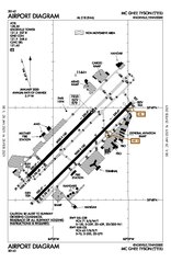
English: McGhee Tyson Airport FAA Airport Diagram January 2021 |
| दिनांक | |
| स्रोत | https://aeronav.faa.gov/d-tpp/2101/00218AD.PDF |
| लेखक | Federal Aviation Administration |
परवाना:
This image or file is a work of a Federal Aviation Administration employee, taken or made as part of that person's official duties. As a work of the U.S. federal government, the image is in the public domain in the United States.
|
 |
संचिकेचा इतिहास
संचिकेची त्यावेळची आवृत्ती बघण्यासाठी त्या दिनांक/वेळेवर टिचकी द्या.
| दिनांक/वेळ | छोटे चित्र | आकार | सदस्य | प्रतिक्रीया | |
|---|---|---|---|---|---|
| सद्य | ०८:३०, ६ फेब्रुवारी २०२१ |  | ८०६ × १,२३७ (१७८ कि.बा.) | Alpacaaviator | Uploaded a work by Federal Aviation Administration from https://aeronav.faa.gov/d-tpp/2101/00218AD.PDF with UploadWizard |
दुवे
खालील पाने या संचिकेला जोडली आहेत: