चित्र:Roman Empire 125 political map.png

या झलकेचा आकार: ७२१ × ५९९ पिक्सेल पिक्सेल. इतर resolutions: २८९ × २४० पिक्सेल | ५७८ × ४८० पिक्सेल | ९२४ × ७६८ पिक्सेल | १,२३२ × १,०२४ पिक्सेल | २,१८६ × १,८१७ पिक्सेल.
मूळ संचिका (२,१८६ × १,८१७ पिक्सेल, संचिकेचा आकार: ३.२१ मे.बा., MIME प्रकार: image/png)
| Camera location | | View this and other nearby images on: OpenStreetMap |
|---|
सारांश
| वर्णन |
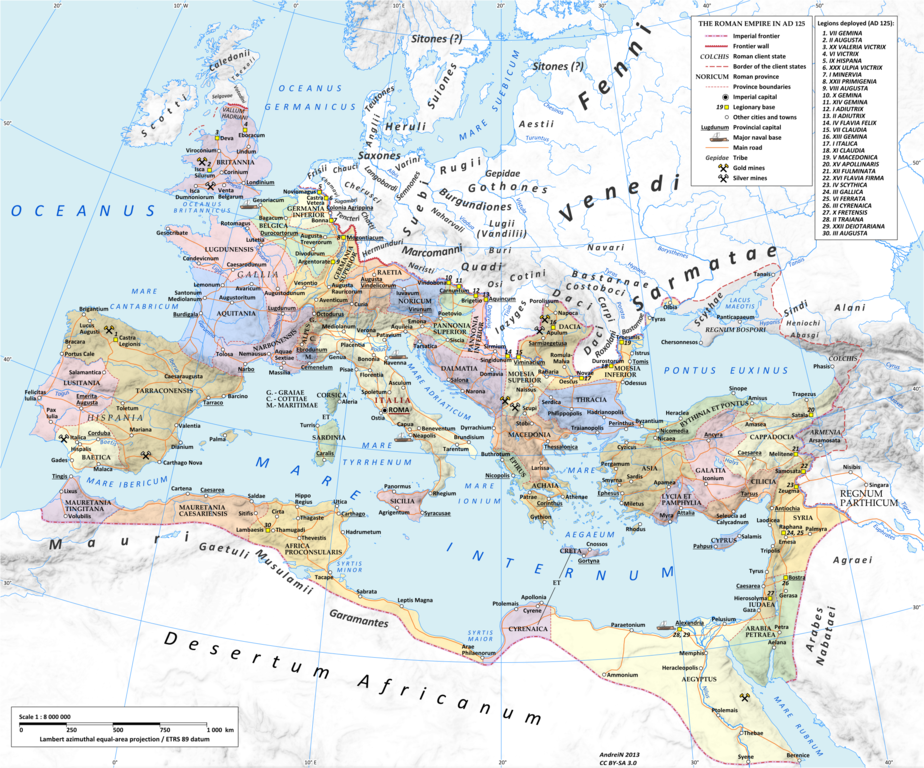
English: Map of the Roman Empire in 125 during the reign of emperor Hadrian.
Projection Lambert azimuthal-equal area. Central latitude: 45° N, central longitude: 20° E. X, Y origin offset - 0 Datum: ETRS89 Sources The physical map was made using the following public domain sources:
Additional references for the map content:
Software used GIS:
Graphics editors:
|
|||
| दिनांक | ||||
| स्रोत | स्वतःचे काम | |||
| लेखक | User:Andrein, with the assistance of EraNavigator | |||
| परवानगी (या संचिकेचा पुनर्वापर करीत आहे) |
Any use of this map can be made as long as you credit me (Andrei N. – Wikimedia Commons user: Andrein) as the author and distribute the copies and derivative works under the same license as that the one stated below. | |||
| इतर आवृत्तींस |
[]
|


परवाना:
मी, या कामाचा/कामाची परवानाधारक, खालील परवान्यांअंतर्गत हे काम येथे प्रकाशित करत आहे :
ही संचिका खालील परवान्याअंतर्गत आहे - क्रीएटिव्ह कॉमन्स Attribution-Share Alike 3.0 Unported.
- तुम्ही मुक्त आहात.
- सामायिक करा – नक्कल, वितरण आणि पारेषित करण्यास
- पुर्नमिश्रीत करण्यास – काम गरजेनुसार अनुकुलीत करण्यास
- खालील अटींच्या अधिन राहून:
- रोपण – आपण योग्य क्रेडिट देणे आवश्यक आहे, परवान्यास दुवा प्रदान करणे आवश्यक आहे, आणि बदल केले गेले आहेत हे दर्शविणे आवश्यक आहे. आपण हे कोणत्याही वाजवी मार्गाने करू शकता, परंतु परवानाधारक आपल्यास किंवा आपल्या वापरास मान्यता देतो अशा कोणत्याही मार्गाने नाही.
- जसेहोते-वाटातसेच (शेअर अलाईक) – जर तुम्ही या कामात काही बदल केलात, काटछाट केलीत, किंवा भर घातली, तर असे करून बनलेले नवीन काम तुम्ही केवळ या किंवा यासारख्याच परवान्याअंतर्गत प्रसारित करू शकतात.

|
फ्री सॉफ्टवेअर फाऊंडेशन द्वारे प्रकाशित जीएनयू मुक्त दस्ताऐवजीकरण परवाना, आवृत्ती १.२ किंवा त्यानंतरची,या अंतर्गत; या दस्तावेजास, नकलविण्याची, वितरणाची व/किंवा फेरबदलाची परवानगी दिल्या जाते या अटींसह कि त्यात कोणतेही निश्चलित(Invariant) विभाग नकोत,पृष्टपान मजकूर नको व मलपान मजकूर नको. GNU Free Documentation License हा मथळा असलेल्या विभागात,या परवान्याची प्रत अंतर्भूत केलेली आहे. |
तुमच्या पसंतीचा परवाना तुम्ही निवडू शकता.
_en.png)
.png)
.jpg)
संचिकेचा इतिहास
संचिकेची त्यावेळची आवृत्ती बघण्यासाठी त्या दिनांक/वेळेवर टिचकी द्या.
| दिनांक/वेळ | छोटे चित्र | आकार | सदस्य | प्रतिक्रीया | |
|---|---|---|---|---|---|
| सद्य | २३:४४, २० जुलै २०१५ | | २,१८६ × १,८१७ (३.२१ मे.बा.) | ArdadN | 1 |
| २३:१९, २० जुलै २०१५ |  | २,१८६ × १,८१७ (३.२१ मे.बा.) | ArdadN | 1 | |
| ००:१६, ४ मार्च २०१५ |  | २,१८६ × १,८१७ (३.२१ मे.बा.) | ArdadN | fixing text problems | |
| २२:३५, ३ मार्च २०१५ |  | २,१८६ × १,८१७ (३.१८ मे.बा.) | ArdadN | new road added | |
| १९:२०, १० फेब्रुवारी २०१५ |  | २,१८६ × १,८१७ (३.२१ मे.बा.) | ArdadN | 1 | |
| ००:१४, २१ मे २०१४ |  | २,१८६ × १,८१७ (३.२ मे.बा.) | ArdadN | 1 | |
| २३:४९, ९ एप्रिल २०१४ |  | २,१८६ × १,८१७ (३.२ मे.बा.) | ArdadN | Scotti | |
| ००:५६, ५ एप्रिल २०१४ |  | २,१८६ × १,८१७ (३.२ मे.बा.) | ArdadN | 1 | |
| १७:१७, ३० मार्च २०१४ |  | २,१८६ × १,८१७ (३.१९ मे.बा.) | ArdadN | removed Scotti, other minor edits | |
| १९:५७, १२ मे २०१३ |  | २,१८६ × १,८१७ (३.२१ मे.बा.) | ArdadN | 1 |
दुवे
खालील पाने या संचिकेला जोडली आहेत:
जागतिक संचिका उपयोग
संचिकाचे इतर विकिपीडियावरील वापरः
- af.wikipedia.org वरील उपयोग
- bn.wikipedia.org वरील उपयोग
- en.wikipedia.org वरील उपयोग
- et.wikipedia.org वरील उपयोग
- gl.wikipedia.org वरील उपयोग
- hu.wikipedia.org वरील उपयोग
- id.wikipedia.org वरील उपयोग
- it.wikipedia.org वरील उपयोग
- ko.wikipedia.org वरील उपयोग
- mk.wikipedia.org वरील उपयोग
- ms.wikipedia.org वरील उपयोग
- pt.wikipedia.org वरील उपयोग