साचा:Infobox map/doc
This template will generate an error message and garbage if it is transcluded with {{{map}}} undefined. This reduces expansion depth which is critical in many infoboxes that transclude this template. |
The parameters {{{label_x}}} and {{{label_y}}} are deprecated. They will remain functional for a time. |
This helper template provides a way to display a map in an Infobox. Optionally a location marker can be included.
Usage
संपादनParameter descriptions
संपादन| Field name | Description |
|---|---|
map |
The name of the map to be displayed. This is the only required parameter. |
map_width |
The width of the map image to be displayed. For example, map_width=220 and not map_width=220px.
|
default_width |
When this template is used in another template, e.g. an infobox, the default width of the map image preferred by the infobox should be specified here. For example, map_width=220. When used with location maps, this value may be modified by a certain value if specified in the location map template. The default value is 220px.
|
relief |
Selects a relief map when assigned any value. This only works when the geographical coordinates method is used and then only for a few maps. See Map display methods. |
map_alt |
Alt text for the map. A visually impaired reader who uses a screen reader will have access to this text. See WP:ALT. |
map_caption |
The caption that appears below the map if one is required. |
mark |
The image file that will be used to mark the location on the map. The default is Red pog.svg. See below. |
mark_width |
The width of the marker image to be displayed. For example, mark_width=8 and not mark_width=8px. The default width is 8px.
|
label |
A text message that will be displayed next to the marker. |
label_position |
The position of a label with respect to the marker. Valid values are left, right, top, bottom and none.
|
latlong |
Specifies the latitude and longitude of the location when the geographical coordinates method is used. This value may be specified as a signed decimal degree. |
lat_deglat_minlat_seclat_dir
|
Specifies the latitude and longitude of the location when the geographical coordinates method is used. This value may be specified in dms+hemisphere format. |
xy |
Specifies the position of the location marker. The coordinates of the marker in pixels based on a map width of 1000 pixels. The template will scale these values for proper display. See below. |
x%y% |
Specifies the position of the location marker. x% specifies the percentage of the distance across the image from the left edge and y% specifies the percentage of the distance down from the top edge. See below.
|
Map display methods
संपादनThere are three methods which can display a mark to on a map. These examples use {{Infobox park}} which uses this template as a back end. साचा:Infobox map/Map display methods
Display any image
संपादनAnother option allows the display of any image without a location mark.
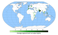
| Average regional brazil nut output (kg/ha) | |
|---|---|
{{Infobox
| above =
| image2 = {{Infobox map
           | map         = Braziloutput.png
           | map_alt     = A world map showing regions that produce Brazil nuts.
           | map_caption =
           | map_width   = 200
           }}
}}
Geographical coordinates
संपादनTo display coordinates in the Infobox two methods can be used. The template {{Infobox coord}} can be used to display coordinates entered using the method discussed above. If the X,Y method is used to display a marker then the template {{coord}} can be used. For examples of coordinate entry see coordinate examples.
TemplateData
संपादनInfobox map साठी टेम्प्लेटडाटा
वर्णन नाही.
| प्राचल | वर्णन | प्रकार | स्थिती | |
|---|---|---|---|---|
| Map | map | The name of the map to be displayed | तंतू | हवे |
| Map Width | map_width | The width of the map image to be displayed. | आकडा | ऐच्छिक |
| Default Width | default_width | When this template is used in another template, the default width is given using this parameter | आकडा | ऐच्छिक |
| Relief | relief | Selects a relief map when assigned any value | तंतू | ऐच्छिक |
| Map Alternative Text | map_alt | Alternative text to be displayed if the map isnt displayed for whatever reasons | तंतू | ऐच्छिक |
| Map Caption | map_caption | Caption for the map | तंतू | ऐच्छिक |
| Mark | mark | The image file that will be used to mark the location on the map | पान | ऐच्छिक |
| Mark Width | mark_width | The width of the marker image to be displayed | आकडा | ऐच्छिक |
| Label | label | A text message that will be displayed next to the marker. | तंतू | ऐच्छिक |
| Label Position | label_position | The position of a label with respect to the marker | तंतू | ऐच्छिक |
| Latitude | lat | Latitude of the map | आकडा | ऐच्छिक |
| Longitude | long | Longitude of the map | आकडा | ऐच्छिक |
| X | x | Specifies the position of x location marker | आकडा | ऐच्छिक |
| Y | y | Specifies the position of y location marker | आकडा | ऐच्छिक |
| X% | x% | x% specifies the percentage of the distance across the image from the left edge | आकडा | ऐच्छिक |
| Y% | y% | y% specifies the percentage of the distance down from the top edge | आकडा | ऐच्छिक |
See also
संपादन- {{Location map}}
- {{Superimpose}}
- Category:Pages using Template:Infobox map needing attention (hidden tracking/maintenance category)

