चित्र:SugarcaneYield.png

या झलकेचा आकार: ८०० × ४८० पिक्सेल पिक्सेल. इतर resolutions: ३२० × १९२ पिक्सेल | १,०२४ × ६१४ पिक्सेल | १,६०० × ९६० पिक्सेल.
मूळ संचिका (१,६०० × ९६० पिक्सेल, संचिकेचा आकार: ४८० कि.बा., MIME प्रकार: image/png)
सारांश
| वर्णन |
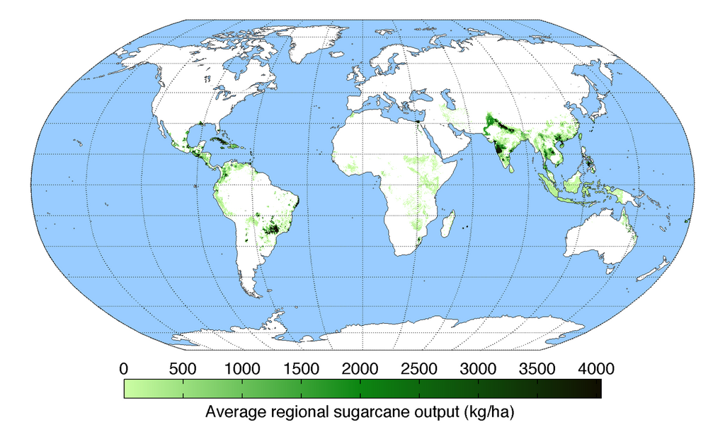
English: Map of sugarcane production (average percentage of land used for its production times average yield in each grid cell) across the world compiled by the University of Minnesota Institute on the Environment with data from: Monfreda, C., N. Ramankutty, and J.A. Foley. 2008. Farming the planet: 2. Geographic distribution of crop areas, yields, physiological types, and net primary production in the year 2000. Global Biogeochemical Cycles 22: GB1022 |
| दिनांक | |
| स्रोत | स्वतःचे काम |
| लेखक | AndrewMT |
परवाना:
I, the copyright holder of this work, hereby publish it under the following license:
ही संचिका खालील परवान्याअंतर्गत आहे - क्रीएटिव्ह कॉमन्स Attribution-Share Alike 3.0 Unported.
- तुम्ही मुक्त आहात.
- सामायिक करा – नक्कल, वितरण आणि पारेषित करण्यास
- पुर्नमिश्रीत करण्यास – काम गरजेनुसार अनुकुलीत करण्यास
- खालील अटींच्या अधिन राहून:
- रोपण – आपण योग्य क्रेडिट देणे आवश्यक आहे, परवान्यास दुवा प्रदान करणे आवश्यक आहे, आणि बदल केले गेले आहेत हे दर्शविणे आवश्यक आहे. आपण हे कोणत्याही वाजवी मार्गाने करू शकता, परंतु परवानाधारक आपल्यास किंवा आपल्या वापरास मान्यता देतो अशा कोणत्याही मार्गाने नाही.
- जसेहोते-वाटातसेच (शेअर अलाईक) – जर तुम्ही या कामात काही बदल केलात, काटछाट केलीत, किंवा भर घातली, तर असे करून बनलेले नवीन काम तुम्ही केवळ या किंवा यासारख्याच परवान्याअंतर्गत प्रसारित करू शकतात.
संचिकेचा इतिहास
संचिकेची त्यावेळची आवृत्ती बघण्यासाठी त्या दिनांक/वेळेवर टिचकी द्या.
| दिनांक/वेळ | छोटे चित्र | आकार | सदस्य | प्रतिक्रीया | |
|---|---|---|---|---|---|
| सद्य | ०१:१८, १३ मे २०१० | | १,६०० × ९६० (४८० कि.बा.) | AndrewMT | Bigger resolution Category:Maps Category:Sugar cane Category:Crops |
| ०३:०४, १८ मार्च २०१० |  | ८०० × ५०० (१९२ कि.बा.) | AndrewMT | reworded title | |
| ०२:५८, ११ मार्च २०१० |  | ८०० × ५०० (१९३ कि.बा.) | AndrewMT | {{Information |Description={{en|1=Map of sugarcane yield across the world (kg/ha) compiled by the University of Minnesota Institute on the Environment with data from:<br> Monfreda, C., N. Ramankutty, and J.A. Foley. 2008. Farming the planet: 2. Geographic |
दुवे
खालील पाने या संचिकेला जोडली आहेत:
जागतिक संचिका उपयोग
संचिकाचे इतर विकिपीडियावरील वापरः
- hak.wikipedia.org वरील उपयोग
- hi.wikipedia.org वरील उपयोग
- hr.wikipedia.org वरील उपयोग
- it.wikipedia.org वरील उपयोग
- ko.wikipedia.org वरील उपयोग
- pt.wikipedia.org वरील उपयोग
- sd.wikipedia.org वरील उपयोग
- sh.wikipedia.org वरील उपयोग
- ur.wikipedia.org वरील उपयोग
- zh.wikipedia.org वरील उपयोग