चित्र:Subtes-2015.svg

Size of this PNG preview of this SVG file: ६९४ × ५९९ पिक्सेल. इतर resolutions: २७८ × २४० पिक्सेल | ५५६ × ४८० पिक्सेल | ८८९ × ७६८ पिक्सेल | १,१८६ × १,०२४ पिक्सेल | २,३७१ × २,०४८ पिक्सेल | १,६५० × १,४२५ पिक्सेल.
मूळ संचिका (SVG संचिका, साधारणपणे १,६५० × १,४२५ pixels, संचिकेचा आकार: १४३ कि.बा.)
| वर्णन |
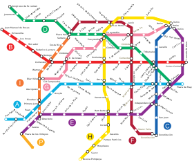
Español: Mapa de la red de subterráneos de la Ciudad de Buenos Aires hacia 2015, con todas las líneas proyectadas según ley 670 de la C.A.B.A.. |
||||||||
| स्रोत | Galio, own work. | ||||||||
| लेखक | Galio | ||||||||
| परवानगी (या संचिकेचा पुनर्वापर करीत आहे) |
मी, या कामाचा/कामाची परवानाधारक, खालील परवान्यांअंतर्गत हे काम येथे प्रकाशित करत आहे :
ही संचिका खालील परवान्याअंतर्गत आहे - क्रीएटिव्ह कॉमन्स Attribution 2.5 Generic.
तुमच्या पसंतीचा परवाना तुम्ही निवडू शकता. |

संचिकेचा इतिहास
संचिकेची त्यावेळची आवृत्ती बघण्यासाठी त्या दिनांक/वेळेवर टिचकी द्या.
| दिनांक/वेळ | छोटे चित्र | आकार | सदस्य | प्रतिक्रीया | |
|---|---|---|---|---|---|
| सद्य | १२:४६, ११ जानेवारी २०१६ | | १,६५० × १,४२५ (१४३ कि.बा.) | SegataSanshiro1 | Smaller station icons, made interchanges clearer. |
| ०१:०५, २ सप्टेंबर २०१५ |  | १,६५० × १,४२५ (१६९ कि.बा.) | SegataSanshiro1 | Colours changed to match official colours, added Premetro | |
| ११:०७, ९ जून २०१३ |  | १,६५० × १,४२५ (१५९ कि.बा.) | Galio | la denominación oficial de las estaciones es S. J. de Flores y San Pedrito, "Flores" a secas y Nazca son obsoletos | |
| ०९:०३, ११ जून २०१० |  | १,६५० × १,४२५ (१३२ कि.बा.) | Dexxter | Estaciones proyectadas de Línea A: Flores y Nazca. | |
| ०५:२२, ९ फेब्रुवारी २००९ |  | १,६५० × १,४२५ (१५९ कि.बा.) | Galio | Modificación ubicación Carabobo | |
| ०५:५०, २६ ऑगस्ट २००८ |  | १,६५० × १,४२५ (१५९ कि.बा.) | Ojota | Category:Buenos Aires Metro | |
| ०८:२७, १४ जुलै २००८ |  | १,६५० × १,४२५ (१५८ कि.बा.) | Galio | {{Information |Description= |Source= |Date= |Author= |Permission= |other_versions= }} | |
| ०६:४८, १४ जुलै २००८ |  | १,६५० × १,४२५ (१५९ कि.बा.) | Galio | {{Information |Description= |Source= |Date= |Author= |Permission= |other_versions= }} {{ImageUpload|basic}} | |
| ०३:४५, १४ जुलै २००८ |  | १,६५० × १,४२५ (१५९ कि.बा.) | Galio | {{Information |Description= |Source= |Date= |Author= |Permission= |other_versions= }} | |
| १२:०५, १३ जुलै २००८ |  | १,६५० × १,४२५ (१६१ कि.बा.) | Galio | == Sumario == Mapa de la red de subterráneos de la Ciudad de Buenos Aires hacia 2015, con todas las líneas proyectadas según ley 670 de la C.A.B.A. == Licensing == {{self2|GFDL|cc-by-2.5}} Category:Public transport maps of Buenos Aires {{ImageUpl |
दुवे
या चित्राशी जोडलेली पृष्ठे नाहीत.
जागतिक संचिका उपयोग
संचिकाचे इतर विकिपीडियावरील वापरः
- ca.wikipedia.org वरील उपयोग
- en.wikipedia.org वरील उपयोग
- es.wikipedia.org वरील उपयोग
- fr.wikipedia.org वरील उपयोग
- hy.wikipedia.org वरील उपयोग
- id.wikipedia.org वरील उपयोग
- it.wikipedia.org वरील उपयोग
- ja.wikipedia.org वरील उपयोग
- nl.wikipedia.org वरील उपयोग
- ru.wikipedia.org वरील उपयोग
- th.wikipedia.org वरील उपयोग
- uk.wikipedia.org वरील उपयोग