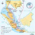
चित्र:Srivijaya Empire.svg

Size of this PNG preview of this SVG file: ४६८ × ४७६ पिक्सेल. इतर resolutions: २३६ × २४० पिक्सेल | ४७२ × ४८० पिक्सेल | ७५५ × ७६८ पिक्सेल | १,००७ × १,०२४ पिक्सेल | २,०१४ × २,०४८ पिक्सेल.
मूळ संचिका (SVG संचिका, साधारणपणे ४६८ × ४७६ pixels, संचिकेचा आकार: ३३६ कि.बा.)
संचिकेचा इतिहास
संचिकेची त्यावेळची आवृत्ती बघण्यासाठी त्या दिनांक/वेळेवर टिचकी द्या.
| दिनांक/वेळ | छोटे चित्र | आकार | सदस्य | प्रतिक्रीया | |
|---|---|---|---|---|---|
| सद्य | ०४:११, ४ डिसेंबर २०१४ |  | ४६८ × ४७६ (३३६ कि.बा.) | Pratyeka | Reposition 'Malacca Straight' label for improved clarity. |
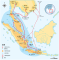
| ०४:०३, ४ डिसेंबर २०१४ |  | ४६८ × ४७६ (३३६ कि.बा.) | Pratyeka | Addition of Lamuri, an important point in northwestern Sumatra identified as contemporary and whose location at Lhok Lambaro is reasoned by E. Edwards McKinnon in ''[http://www.scribd.com/doc/8410125/A-note-of-Lamuri-Lambri-Sumatra-Straits-of-Melaka-Ma... | |
| ००:४५, २७ ऑगस्ट २००९ |  | ४६८ × ४७६ (२८८ कि.बा.) | Gunkarta | {{Information |Description={{en|1=Maximum extent of Srivijaya Empire around 8th century. Expanding from Sumatra, Central Java, to Malay Peninsula. The red arrows show the series of Srivijayan expedition and conquest, in diplomatic alliances, military camp |
दुवे
खालील पाने या संचिकेला जोडली आहेत:
जागतिक संचिका उपयोग
संचिकाचे इतर विकिपीडियावरील वापरः
- azb.wikipedia.org वरील उपयोग
- ba.wikipedia.org वरील उपयोग
- be.wikipedia.org वरील उपयोग
- bg.wikipedia.org वरील उपयोग
- bn.wikipedia.org वरील उपयोग
- ca.wikipedia.org वरील उपयोग
- cs.wikipedia.org वरील उपयोग
- da.wikipedia.org वरील उपयोग
- en.wikipedia.org वरील उपयोग
- eo.wikipedia.org वरील उपयोग
- fa.wikipedia.org वरील उपयोग
- fi.wikibooks.org वरील उपयोग
- ha.wikipedia.org वरील उपयोग
- hi.wikipedia.org वरील उपयोग
- hu.wikipedia.org वरील उपयोग
- hy.wikipedia.org वरील उपयोग
- id.wikipedia.org वरील उपयोग
- io.wikipedia.org वरील उपयोग
- it.wikipedia.org वरील उपयोग
- ja.wikipedia.org वरील उपयोग
- ja.wikibooks.org वरील उपयोग
- ka.wikipedia.org वरील उपयोग
- km.wikipedia.org वरील उपयोग
- ko.wikipedia.org वरील उपयोग
- lt.wikipedia.org वरील उपयोग
- lv.wikipedia.org वरील उपयोग
- min.wikipedia.org वरील उपयोग
- ml.wikipedia.org वरील उपयोग
- ms.wikipedia.org वरील उपयोग
या संचिकेचे अधिक वैश्विक उपयोग पहा


