चित्र:Satsunan Islands.png

या झलकेचा आकार: ४३२ × ६०० पिक्सेल पिक्सेल. इतर resolutions: १७३ × २४० पिक्सेल | ३४६ × ४८० पिक्सेल | ७८० × १,०८३ पिक्सेल.
मूळ संचिका (७८० × १,०८३ पिक्सेल, संचिकेचा आकार: ७६ कि.बा., MIME प्रकार: image/png)

|
This locator map image could be re-created using vector graphics as an SVG file. This has several advantages; see Commons:Media for cleanup for more information. If an SVG form of this image is available, please upload it and afterwards replace this template with
{{vector version available|new image name}}.
It is recommended to name the SVG file “Satsunan Islands.svg”—then the template Vector version available (or Vva) does not need the new image name parameter. |
सारांश
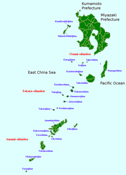
| वर्णन | Map of the Satsunan Islands (Ōsumi Islands + Tokara Islands + Amami Islands), Ryukyu , Japan |
| दिनांक | (UTC) |
| स्रोत | स्वतःचे काम |
| लेखक | Krisgrotius |
| इतर आवृत्तींस |
Derivative works of this file: |
परवाना:
| I, the copyright holder of this work, release this work into the public domain. This applies worldwide. असे करणे काही देशांमधे कायद्यानुसार शक्य नसू शकते. असे असल्यास : मी कोणालाही कोणत्याही कारणासाठी हे काम वापरण्याचे अधिकार कोणत्याही बंधनाशिवाय जर अशी बंधने कायद्याने बंधनकारक नसतीलतर देत आहोत. |
संचिकेचा इतिहास
संचिकेची त्यावेळची आवृत्ती बघण्यासाठी त्या दिनांक/वेळेवर टिचकी द्या.
| दिनांक/वेळ | छोटे चित्र | आकार | सदस्य | प्रतिक्रीया | |
|---|---|---|---|---|---|
| सद्य | २१:४६, ५ जानेवारी २००७ | | ७८० × १,०८३ (७६ कि.बा.) | Krisgrotius | {{Information |Description=Map of the Satsunan Islands (Ōsumi Islands + Tokara Islands + Amami Islands), Ryukyu , Japan |Source= own work |Date=~~~~~ |Author=~~~ |Permission= |other_versions= public }} |
दुवे
या चित्राशी जोडलेली पृष्ठे नाहीत.
जागतिक संचिका उपयोग
संचिकाचे इतर विकिपीडियावरील वापरः
- cy.wikipedia.org वरील उपयोग
- fa.wikipedia.org वरील उपयोग
- nl.wikipedia.org वरील उपयोग