चित्र:Road network CPEC.jpg
या झलकेचा आकार: ७९९ × ६०० पिक्सेल पिक्सेल. इतर resolutions: ३२० × २४० पिक्सेल | ६४० × ४८० पिक्सेल | ९६२ × ७२२ पिक्सेल.
मूळ संचिका (९६२ × ७२२ पिक्सेल, संचिकेचा आकार: १३७ कि.बा., MIME प्रकार: image/jpeg)
सारांश
| वर्णन |
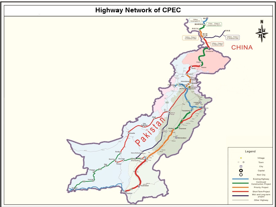
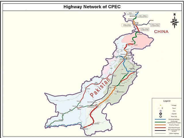
English: It describes Eastern Western and Central alignment of CPEC |
| दिनांक | |
| स्रोत | http://www.pc.gov.pk/wp-content/uploads/2016/01/Highway-Network-of-cpac-new.jpg |
| लेखक | Government of Pakistan |
This file is in the public domain because Planning commision of Pakistan
|
संचिकेचा इतिहास
संचिकेची त्यावेळची आवृत्ती बघण्यासाठी त्या दिनांक/वेळेवर टिचकी द्या.
| दिनांक/वेळ | छोटे चित्र | आकार | सदस्य | प्रतिक्रीया | |
|---|---|---|---|---|---|
| सद्य | ०५:४९, २८ सप्टेंबर २०२३ | | ९६२ × ७२२ (१३७ कि.बा.) | Eggrollll | Reverted to version as of 17:10, 4 December 2020 (UTC) |
| २२:४१, ४ डिसेंबर २०२० |  | ९६२ × ७२२ (१२५ कि.बा.) | Pathfinder454 | Map published by user Badri2017 is forged / edited without copyrights obtained from Government of Pakistan. Original file published by user Baltistani478 is the actual map depicting road networks of CPEC as published at official website http://cpec.gov.pk/map-single/1 Therefore File Reverted to version as of 16:49, 23 May 2016 (UTC) | |
| २२:४०, ४ डिसेंबर २०२० |  | ९६२ × ७२२ (१३७ कि.बा.) | Pathfinder454 | Reverted to version as of 10:15, 19 July 2017 (UTC) Map published by user Badri2017 is forged / edited without copyrights obtained from Government of Pakistan. Original file published by user Baltistani478 is the actual map depicting road networks of CPEC as published at official website http://cpec.gov.pk/map-single/1 Therefore File Reverted to version as of 16:49, 23 May 2016 (UTC | |
| २२:३१, ४ डिसेंबर २०२० |  | ९६२ × ७२२ (१२५ कि.बा.) | Pathfinder454 | Map published by user Badri2017 is forged / edited without copyrights obtained from Government of Pakistan. Original file published by user Baltistani478 is the actual map depicting road networks of CPEC as published at official website http://cpec.gov.pk/map-single/1 Therefore File Reverted to version as of 16:49, 23 May 2016 (UTC) | |
| १५:४५, १९ जुलै २०१७ |  | ९६२ × ७२२ (१३७ कि.बा.) | Badri2017 | Neutral Map, Indian administered Kashmir is neither part of CPEC nor Pak territory | |
| २२:१९, २३ मे २०१६ |  | ९६२ × ७२२ (१२५ कि.बा.) | Baltistani478 | {{subst:Upload marker added by en.wp UW}} {{Information |Description = {{en|It describes Eastern Western and Central alignment of CPEC}} |Source = http://www.pc.gov.pk/wp-content/uploads/2016/01/Highway-Network-of-cpac-new.jpg |Date = January 2016 |Aut... |
दुवे
खालील पाने या संचिकेला जोडली आहेत:
जागतिक संचिका उपयोग
संचिकाचे इतर विकिपीडियावरील वापरः
- ar.wikipedia.org वरील उपयोग
- bn.wikipedia.org वरील उपयोग
- ca.wikipedia.org वरील उपयोग
- en.wikipedia.org वरील उपयोग
- eo.wikinews.org वरील उपयोग
- hi.wikipedia.org वरील उपयोग
- pa.wikipedia.org वरील उपयोग
- pnb.wikipedia.org वरील उपयोग
- sat.wikipedia.org वरील उपयोग
- sd.wikipedia.org वरील उपयोग
- ta.wikipedia.org वरील उपयोग
- zh.wikipedia.org वरील उपयोग