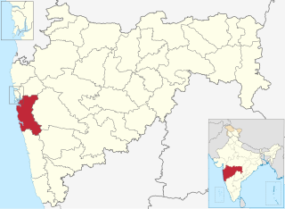
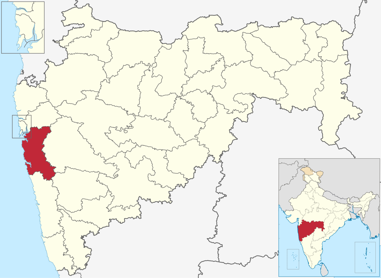
चित्र:Raigad in Maharashtra (India).svg

Size of this PNG preview of this SVG file: ८०० × ५८५ पिक्सेल. इतर resolutions: ३२० × २३४ पिक्सेल | ६४० × ४६८ पिक्सेल | १,०२४ × ७४८ पिक्सेल | १,२८० × ९३५ पिक्सेल | २,५६० × १,८७१ पिक्सेल | १,२३३ × ९०१ पिक्सेल.
मूळ संचिका (SVG संचिका, साधारणपणे १,२३३ × ९०१ pixels, संचिकेचा आकार: १.१६ मे.बा.)
.svg)
| वर्णन | Map of Raigad district of Maharashtra |
| दिनांक | 2 March 2021 |
| स्रोत | Derivative of File:India Maharashtra location map.svg |
| लेखक | Own work based on User:Chumwa |
| परवानगी (या संचिकेचा पुनर्वापर करीत आहे) |
ही संचिका खालील परवान्याअंतर्गत आहे - क्रीएटिव्ह कॉमन्स Attribution-Share Alike 3.0 Unported.
|
Category:Districts of Maharashtra
संचिकेचा इतिहास
संचिकेची त्यावेळची आवृत्ती बघण्यासाठी त्या दिनांक/वेळेवर टिचकी द्या.
| दिनांक/वेळ | छोटे चित्र | आकार | सदस्य | प्रतिक्रीया | |
|---|---|---|---|---|---|
| सद्य | २३:२०, ४ जुलै २०२३ | | १,२३३ × ९०१ (१.१६ मे.बा.) | C1MM | updated bounds |
| १०:३३, १ मे २०२२ |  | १,१४६ × ८३८ (८०५ कि.बा.) | C1MM | updated bounds | |
| २०:४१, ६ जून २०२१ |  | १,२२३ × ८९४ (१.२४ मे.बा.) | C1MM | c bounds | |
| ०८:०३, ३ मार्च २०२१ |  | ८७५ × ६४० (७६७ कि.बा.) | C1MM | {{Information|Description=Map of Raigad district of Maharashtra|Source=Derivative of File:India Maharashtra location map.svg|Date=2 March 2021|Author=Own work based on User:Chumwa|Permission={{Cc-by-sa-3.0}}}} Category:Districts of Maharashtra |
दुवे
खालील पाने या संचिकेला जोडली आहेत:
जागतिक संचिका उपयोग
संचिकाचे इतर विकिपीडियावरील वापरः
- ar.wikipedia.org वरील उपयोग
- arz.wikipedia.org वरील उपयोग
- bn.wikipedia.org वरील उपयोग
- ca.wikipedia.org वरील उपयोग
- de.wikipedia.org वरील उपयोग
- en.wikipedia.org वरील उपयोग
- Uran
- Alibag
- Matheran
- Karjat
- Roha
- Panvel
- Chaul
- Neral, India
- Kashid
- Revdanda
- Raigad district
- Khopoli
- Lonere
- Wahal
- Mahad
- Ambivali Tarf Tungaratan
- Birwadi
- Dhatau
- Kalundre
- Kegaon
- Kherdi
- Mhasla
- Mohpada
- Murud, Raigad
- Nagothane
- Poladpur
- Roha Ashtami
- Shrivardhan
- Taloje Panchnand
- Utekhol
- Sarasgad
- Rasayani
- Bamandongri
- Devale, Raigad
- Khalapur
- Mangaon
- Pen, India
- Pali, Raigad
- Mora, Maharashtra
- Shelu
- Chikhale, Panvel
- Rajpuri, Raigad
- Goregaon (Raigad)
- Bhivpuri
- Khandas
या संचिकेचे अधिक वैश्विक उपयोग पहा
.svg)
.svg)