चित्र:Pridnestrian Administration.png

या झलकेचा आकार: ४०८ × ५९९ पिक्सेल पिक्सेल. इतर resolutions: १६३ × २४० पिक्सेल | ३२७ × ४८० पिक्सेल | ९२२ × १,३५४ पिक्सेल.
मूळ संचिका (९२२ × १,३५४ पिक्सेल, संचिकेचा आकार: ५१ कि.बा., MIME प्रकार: image/png)

|
This map image could be re-created using vector graphics as an SVG file. This has several advantages; see Commons:Media for cleanup for more information. If an SVG form of this image is available, please upload it and afterwards replace this template with
{{vector version available|new image name}}.
It is recommended to name the SVG file “Pridnestrian Administration.svg”—then the template Vector version available (or Vva) does not need the new image name parameter. |
सारांश
| वर्णन |
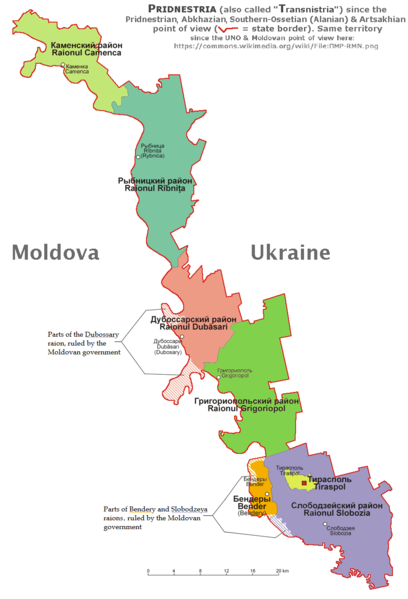
English: English and according with the official Pridnestrian point of view administrative map of Pridnestria, by Nicolay Sidorov. |
| दिनांक | |
| स्रोत | स्वतःचे काम |
| लेखक | derivative map by Spiridon Ion Cepleanu since Aotearoa's map File:Naddniestrze.png, modified by Николай Сидоров, details by Claude Zygiel according with this [1] official Pridnestrian map. |
| इतर आवृत्तींस | File:ПМР-RMN.png showing the UNO & Moldovan point of view about this territory. |
परवाना:
I, the copyright holder of this work, hereby publish it under the following license:
This file is licensed under the Creative Commons Attribution-Share Alike 4.0 International license.
- तुम्ही मुक्त आहात.
- सामायिक करा – नक्कल, वितरण आणि पारेषित करण्यास
- पुर्नमिश्रीत करण्यास – काम गरजेनुसार अनुकुलीत करण्यास
- खालील अटींच्या अधिन राहून:
- रोपण – आपण योग्य क्रेडिट देणे आवश्यक आहे, परवान्यास दुवा प्रदान करणे आवश्यक आहे, आणि बदल केले गेले आहेत हे दर्शविणे आवश्यक आहे. आपण हे कोणत्याही वाजवी मार्गाने करू शकता, परंतु परवानाधारक आपल्यास किंवा आपल्या वापरास मान्यता देतो अशा कोणत्याही मार्गाने नाही.
- जसेहोते-वाटातसेच (शेअर अलाईक) – जर तुम्ही या कामात काही बदल केलात, काटछाट केलीत, किंवा भर घातली, तर असे करून बनलेले नवीन काम तुम्ही केवळ या किंवा यासारख्याच परवान्याअंतर्गत प्रसारित करू शकतात.
संचिकेचा इतिहास
संचिकेची त्यावेळची आवृत्ती बघण्यासाठी त्या दिनांक/वेळेवर टिचकी द्या.
| दिनांक/वेळ | छोटे चित्र | आकार | सदस्य | प्रतिक्रीया | |
|---|---|---|---|---|---|
| सद्य | १४:२८, २२ जानेवारी २०२० | | ९२२ × १,३५४ (५१ कि.बा.) | Claude Zygiel | Southern Ossetia-Alania & Artsakhian also |
| २२:५७, २० जानेवारी २०२० |  | ९२२ × १,३५४ (५० कि.बा.) | Claude Zygiel | According with the Wikipedia's rules. | |
| १५:२५, १४ ऑक्टोबर २०१९ |  | ९२२ × १,३५४ (४७ कि.बा.) | Nicolay Sidorov | Reverted to version as of 12:22, 6 July 2018 (UTC) See discussion | |
| १५:५८, १० मे २०१९ | ६३६ × १,८७५ (३७४ कि.बा.) | Claude Zygiel | The both points of view, de jure and de facto | ||
| १७:५२, ६ जुलै २०१८ |  | ९२२ × १,३५४ (४७ कि.बा.) | Nicolay Sidorov | Reverted to version as of 09:24, 6 March 2017 (UTC) Borders of Transnistrian autonomous unit (moldovan) is only wishes of Moldova, not a de-facto transnistria border | |
| ०१:०६, १४ ऑगस्ट २०१७ |  | ९२२ × १,३५४ (५९ कि.बा.) | MAXHO | According with all sources and travellers, with NordNordWest's map [https://commons.wikimedia.org/wiki/File:Moldova_location_map.svg], with Aotearoa's original maps [https://commons.wikimedia.org/wiki/File:Naddniestrze.png], [https://commons.wikimedia.... | |
| १४:५४, ६ मार्च २०१७ |  | ९२२ × १,३५४ (४७ कि.बा.) | Nicolay Sidorov | fix borders | |
| १७:५६, १६ ऑक्टोबर २०१५ |  | ९२२ × १,३५४ (१३७ कि.बा.) | RokerHRO | optipng -o7 -i0 -zc1-9 -zm1-9 -zs0-3 -f0-5 → 19.02% decrease | |
| २१:४८, ५ ऑगस्ट २०१५ |  | ९२२ × १,३५४ (१६९ कि.बा.) | Spiridon Ion Cepleanu | User created page with UploadWizard |
दुवे
खालील पाने या संचिकेला जोडली आहेत:
जागतिक संचिका उपयोग
संचिकाचे इतर विकिपीडियावरील वापरः
- af.wikipedia.org वरील उपयोग
- ar.wikipedia.org वरील उपयोग
- bs.wikipedia.org वरील उपयोग
- cs.wikipedia.org वरील उपयोग
- de.wikipedia.org वरील उपयोग
- de.wikivoyage.org वरील उपयोग
- el.wikipedia.org वरील उपयोग
- en.wikipedia.org वरील उपयोग
- es.wikipedia.org वरील उपयोग
- et.wikipedia.org वरील उपयोग
- eu.wikipedia.org वरील उपयोग
- fi.wikipedia.org वरील उपयोग
- fr.wikipedia.org वरील उपयोग
- gl.wikipedia.org वरील उपयोग
- hu.wikipedia.org वरील उपयोग
- hy.wikipedia.org वरील उपयोग
- id.wikipedia.org वरील उपयोग
- is.wikipedia.org वरील उपयोग
- it.wikivoyage.org वरील उपयोग
- ja.wikipedia.org वरील उपयोग
- li.wikipedia.org वरील उपयोग
- lt.wikipedia.org वरील उपयोग
- mg.wikipedia.org वरील उपयोग
- mn.wikipedia.org वरील उपयोग
- nds-nl.wikipedia.org वरील उपयोग
- no.wikipedia.org वरील उपयोग
- pt.wikipedia.org वरील उपयोग
- ro.wikipedia.org वरील उपयोग
- sl.wikipedia.org वरील उपयोग
- sr.wikipedia.org वरील उपयोग
- sv.wikipedia.org वरील उपयोग
- tl.wikipedia.org वरील उपयोग
- uk.wikipedia.org वरील उपयोग
- zh-yue.wikipedia.org वरील उपयोग
- zh.wikipedia.org वरील उपयोग