चित्र:Oceans and seas boundaries map-en.svg

Size of this PNG preview of this SVG file: ८०० × ४०६ पिक्सेल. इतर resolutions: ३२० × १६२ पिक्सेल | ६४० × ३२५ पिक्सेल | १,०२४ × ५१९ पिक्सेल | १,२८० × ६४९ पिक्सेल | २,५६० × १,२९९ पिक्सेल | ४,००० × २,०२९ पिक्सेल.
मूळ संचिका (SVG संचिका, साधारणपणे ४,००० × २,०२९ pixels, संचिकेचा आकार: १.३९ मे.बा.)
सारांश
| वर्णन |
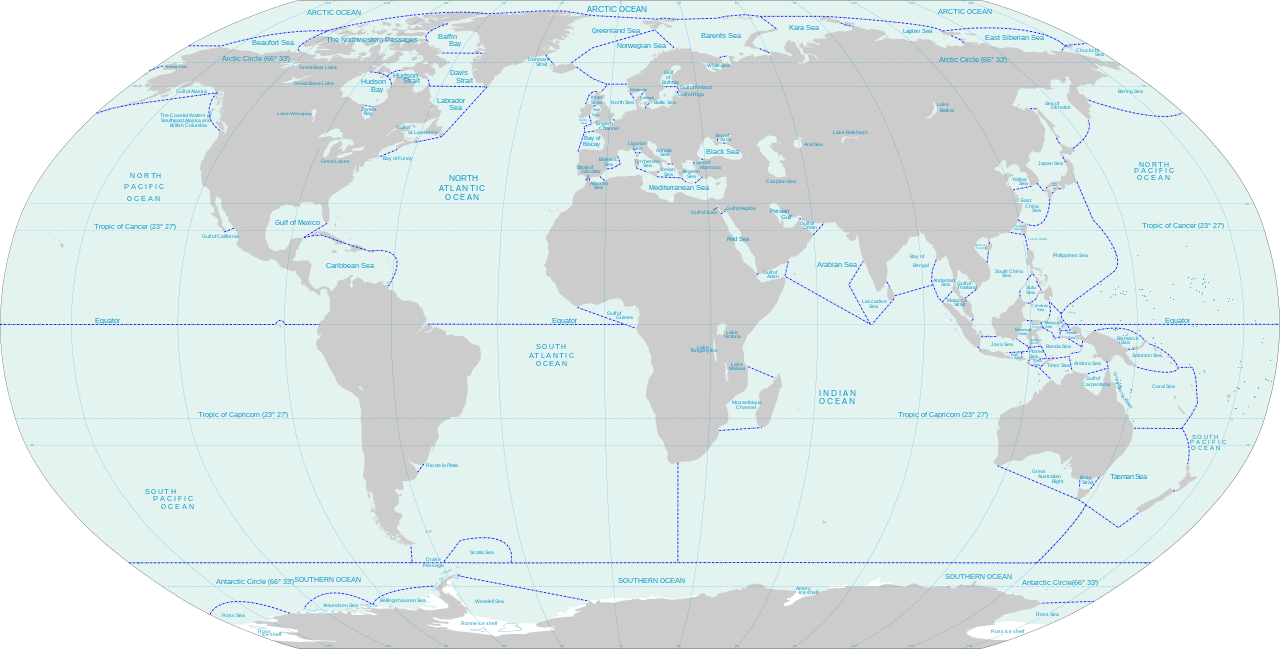
English: World map of oceans and seas : English version |
| दिनांक | (UTC) |
| स्रोत |
Own work using:
|
| लेखक | |
| इतर आवृत्तींस | Turkish version, French version |
| This is a retouched picture, which means that it has been digitally altered from its original version. Modifications: Translated remaining French labels, fixed some English labels, added missing sea and lake names, added missing lake, refactored text styling of some labels to match the rest, fixed rainbow of colors assigned to random islands, added missing Malta and Bermuda islands. The original can be viewed here: Oceans and seas boundaries map-en.svg:
|
मी, या कामाचा/कामाची परवानाधारक, खालील परवान्यांअंतर्गत हे काम येथे प्रकाशित करत आहे :
ही संचिका खालील परवान्यांअंतर्गत आहे - क्रीएटिव्ह कॉमन्स Attribution-Share Alike 3.0 Unported, 2.5 Generic, 2.0 Generic आणि 1.0 Generic.
- तुम्ही मुक्त आहात.
- सामायिक करा – नक्कल, वितरण आणि पारेषित करण्यास
- पुर्नमिश्रीत करण्यास – काम गरजेनुसार अनुकुलीत करण्यास
- खालील अटींच्या अधिन राहून:
- रोपण – आपण योग्य क्रेडिट देणे आवश्यक आहे, परवान्यास दुवा प्रदान करणे आवश्यक आहे, आणि बदल केले गेले आहेत हे दर्शविणे आवश्यक आहे. आपण हे कोणत्याही वाजवी मार्गाने करू शकता, परंतु परवानाधारक आपल्यास किंवा आपल्या वापरास मान्यता देतो अशा कोणत्याही मार्गाने नाही.
- जसेहोते-वाटातसेच (शेअर अलाईक) – जर तुम्ही या कामात काही बदल केलात, काटछाट केलीत, किंवा भर घातली, तर असे करून बनलेले नवीन काम तुम्ही केवळ या किंवा यासारख्याच परवान्याअंतर्गत प्रसारित करू शकतात.

|
फ्री सॉफ्टवेअर फाऊंडेशन द्वारे प्रकाशित जीएनयू मुक्त दस्ताऐवजीकरण परवाना, आवृत्ती १.२ किंवा त्यानंतरची,या अंतर्गत; या दस्तावेजास, नकलविण्याची, वितरणाची व/किंवा फेरबदलाची परवानगी दिल्या जाते या अटींसह कि त्यात कोणतेही निश्चलित(Invariant) विभाग नकोत,पृष्टपान मजकूर नको व मलपान मजकूर नको. GNU Free Documentation License हा मथळा असलेल्या विभागात,या परवान्याची प्रत अंतर्भूत केलेली आहे. |
तुमच्या पसंतीचा परवाना तुम्ही निवडू शकता.
चढवल्याचे मुळ विवरण
This image is a derivative work of the following images:
- File:Oceans and seas boundaries map-fr.svg licensed with Cc-by-sa-3.0,2.5,2.0,1.0, GFDL
- 2021-04-05T01:32:50Z Dziban303 2753x1538 (1276318 Bytes) == {{int:filedesc}} == {{Information |Description={{en|World map of oceans and seas : English version}} |Source={{Derived from|Oceans and seas boundaries map-en.svg|display=50}} |Date=2021-04-05 01:09 (UTC) |Author=* [[:File:
- 2021-04-04T21:12:48Z Dziban303 2753x1538 (1268270 Bytes) == {{int:filedesc}} == {{Information |Description=English: World map of oceans and seas : English version|Source={{Derived from|Oceans and seas boundaries map-en.svg|display=50}} |Date=2021-04-04 21:10 (UTC) |Author=* [[:File:
- 2011-02-13T11:57:29Z Jugger90 2753x1538 (1263323 Bytes) {{Information |Description={{en|World map of oceans and seas : french version}} {{fr|Carte des océans et des mers du monde : version vide}} |Source=*[[:File:Oceans_and_seas_boundaries_map-fr.svg|]] |Date=2011-02-13 11:56 (UT
Uploaded with derivativeFX
संचिकेचा इतिहास
संचिकेची त्यावेळची आवृत्ती बघण्यासाठी त्या दिनांक/वेळेवर टिचकी द्या.
| दिनांक/वेळ | छोटे चित्र | आकार | सदस्य | प्रतिक्रीया | |
|---|---|---|---|---|---|
| सद्य | १९:४१, ११ जून २०२१ | | ४,००० × २,०२९ (१.३९ मे.बा.) | Ibrahim Muizzuddin | Edit toponymy, resize |
| १९:०५, ११ जून २०२१ |  | २,७५३ × १,३९६ (१.२२ मे.बा.) | Ibrahim Muizzuddin | Fit image | |
| ०७:४३, ५ एप्रिल २०२१ |  | २,७५३ × १,५३८ (१.२२ मे.बा.) | Dziban303 | == {{int:filedesc}} == {{Information |Description={{en|World map of oceans and seas — English version}} |Source={{Derived from|Oceans and seas boundaries map-en.svg|display=50}} |Date=2021-04-05 02:11 (UTC) |Author=* File:Oceans and seas boundaries map-en.svg: *Oceans_and_seas_boundaries_map-fr.svg: Pinpin * derivative work: Jugger90 ([[User talk:Jugger90|<span cla... | |
| ०७:०२, ५ एप्रिल २०२१ |  | २,७५३ × १,५३८ (१.२२ मे.बा.) | Dziban303 | == {{int:filedesc}} == {{Information |Description={{en|World map of oceans and seas : English version}} |Source={{Derived from|Oceans and seas boundaries map-en.svg|display=50}} |Date=2021-04-05 01:09 (UTC) |Author=* File:Oceans and seas boundaries map-en.svg: *Oceans_and_seas_boundaries_map-fr.svg: Pinpin *derivative work: Jugger90 ([[User talk:Jugger90|<span clas... | |
| ०२:४२, ५ एप्रिल २०२१ |  | २,७५३ × १,५३८ (१.२१ मे.बा.) | Dziban303 | == {{int:filedesc}} == {{Information |Description={{en|World map of oceans and seas : English version}} |Source={{Derived from|Oceans and seas boundaries map-en.svg|display=50}} |Date=2021-04-04 21:10 (UTC) |Author=* File:Oceans and seas boundaries map-en.svg: *Oceans_and_seas_boundaries_map-fr.svg: Pinpin *derivative work: Jugger90 ([[User talk:Jugger90|<span clas... | |
| १७:२७, १३ फेब्रुवारी २०११ |  | २,७५३ × १,५३८ (१.२ मे.बा.) | Jugger90 | {{Information |Description={{en|World map of oceans and seas : french version}} {{fr|Carte des océans et des mers du monde : version vide}} |Source=*File:Oceans_and_seas_boundaries_map-fr.svg |Date=2011-02-13 11:56 (UTC) |Author=*[[:File:Oceans_and |
दुवे
खालील पाने या संचिकेला जोडली आहेत:
जागतिक संचिका उपयोग
संचिकाचे इतर विकिपीडियावरील वापरः
- ar.wikipedia.org वरील उपयोग
- ast.wikipedia.org वरील उपयोग
- bh.wikipedia.org वरील उपयोग
- blk.wikipedia.org वरील उपयोग
- bs.wikipedia.org वरील उपयोग
- ceb.wikipedia.org वरील उपयोग
- da.wikipedia.org वरील उपयोग
- de.wikipedia.org वरील उपयोग
- el.wikipedia.org वरील उपयोग
- en.wikipedia.org वरील उपयोग
- eo.wikipedia.org वरील उपयोग
- es.wikipedia.org वरील उपयोग
- eu.wikipedia.org वरील उपयोग
- fa.wikipedia.org वरील उपयोग
- fi.wikipedia.org वरील उपयोग
- id.wikipedia.org वरील उपयोग
- ilo.wikipedia.org वरील उपयोग
- it.wikipedia.org वरील उपयोग
- ka.wikipedia.org वरील उपयोग
- kn.wikipedia.org वरील उपयोग
- mk.wikipedia.org वरील उपयोग
- mn.wikipedia.org वरील उपयोग
- ms.wikipedia.org वरील उपयोग
- ru.wikipedia.org वरील उपयोग
- sh.wikipedia.org वरील उपयोग
- sl.wikipedia.org वरील उपयोग
- sn.wikipedia.org वरील उपयोग
- sv.wikipedia.org वरील उपयोग
- th.wikipedia.org वरील उपयोग
- ur.wikipedia.org वरील उपयोग
- vi.wikipedia.org वरील उपयोग
- zh.wikipedia.org वरील उपयोग