चित्र:Ocean currents 1943 (borderless)3.png

या झलकेचा आकार: ८०० × ४०५ पिक्सेल पिक्सेल. इतर resolutions: ३२० × १६२ पिक्सेल | ६४० × ३२४ पिक्सेल | १,०२४ × ५१९ पिक्सेल | १,२८० × ६४९ पिक्सेल | २,५७७ × १,३०६ पिक्सेल.
मूळ संचिका (२,५७७ × १,३०६ पिक्सेल, संचिकेचा आकार: २.४१ मे.बा., MIME प्रकार: image/png)

|
This meteorology image could be re-created using vector graphics as an SVG file. This has several advantages; see Commons:Media for cleanup for more information. If an SVG form of this image is available, please upload it and afterwards replace this template with
{{vector version available|new image name}}.
It is recommended to name the SVG file “Ocean currents 1943 (borderless)3.svg”—then the template Vector version available (or Vva) does not need the new image name parameter. |
सारांश
| वर्णन |
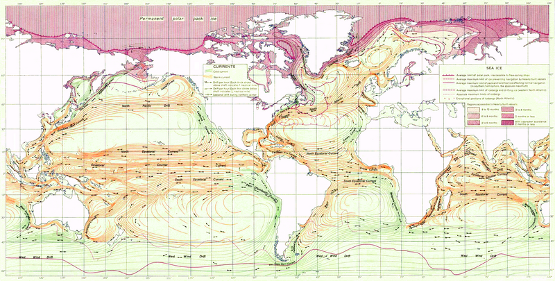
English: Ocean Currents and Sea Ice from Atlas of World Maps, United States Army Service Forces, Army Specialized Training Division. Army Service Forces Manual M-101 (1943).
Türkçe: Dünyanın büyük akıntılarının şeması |
|||
| दिनांक | ||||
| स्रोत | Edited version of File:Ocean currents 1943 (borderless).png | |||
| लेखक | US army | |||
| परवानगी (या संचिकेचा पुनर्वापर करीत आहे) |
|
|||
| इतर आवृत्तींस |
This file was derived from: Ocean currents 1943 (borderless).png (For more versions see there) |

.png)
3.png)
.png)
| This is a retouched picture, which means that it has been digitally altered from its original version. Modifications: landmass interiors clarified, some latitude and longitude lines repaired, bottom longitudinal numbering replaced, and a stray pencil mark through the Indian Ocean removed. The original can be viewed here: Ocean currents 1943 (borderless).png:
|
Assessment
|
3.png)
संचिकेचा इतिहास
संचिकेची त्यावेळची आवृत्ती बघण्यासाठी त्या दिनांक/वेळेवर टिचकी द्या.
| दिनांक/वेळ | छोटे चित्र | आकार | सदस्य | प्रतिक्रीया | |
|---|---|---|---|---|---|
| सद्य | ०२:४८, ३ फेब्रुवारी २०१२ | | २,५७७ × १,३०६ (२.४१ मे.बा.) | Mahahahaneapneap | Compressed again. Please don't revert unless you can give a reason why. |
| ०३:१८, २० जानेवारी २०१२ |  | २,५७७ × १,३०६ (३.४ मे.बा.) | The ed17 | there is no reason to compress this | |
| २३:५७, २४ डिसेंबर २०११ |  | २,५७७ × १,३०६ (२.४१ मे.बा.) | Mahahahaneapneap | Compressed. Identical image, 1 MB smaller. | |
| २०:०४, ४ सप्टेंबर २००९ |  | २,५७७ × १,३०६ (३.४ मे.बा.) | Durova | Reverted to version as of 08:15, 27 June 2008 reverting arbitrary compression | |
| ०२:२४, १८ ऑक्टोबर २००८ |  | २,५७७ × १,३०६ (२.४१ मे.बा.) | Mahahahaneapneap | Compressed | |
| १३:४५, २७ जून २००८ |  | २,५७७ × १,३०६ (३.४ मे.बा.) | Durova | {{Information |Description=''Ocean Currents and Sea Ice from Atlas of World Maps'', United States Army Service Forces, Army Specialized Training Division. Army Service Forces Manual M-101 (1943). |Source=http://www.lib.utexas.edu/maps/world_maps/ocean |
दुवे
खालील पाने या संचिकेला जोडली आहेत:
जागतिक संचिका उपयोग
संचिकाचे इतर विकिपीडियावरील वापरः
- ar.wikipedia.org वरील उपयोग
- ast.wikipedia.org वरील उपयोग
- az.wikipedia.org वरील उपयोग
- be.wikipedia.org वरील उपयोग
- bg.wikipedia.org वरील उपयोग
- bn.wikipedia.org वरील उपयोग
- ca.wikipedia.org वरील उपयोग
- da.wikipedia.org वरील उपयोग
- el.wikipedia.org वरील उपयोग
- en.wikipedia.org वरील उपयोग
- Ocean current
- Portal:Maps/Selected picture
- History of navigation
- Wikipedia:Featured pictures thumbs/12
- Wikipedia:Featured pictures/Diagrams, drawings, and maps/Maps
- User:Shoemaker's Holiday
- Wikipedia:Featured picture candidates/File:Ocean currents 1943 (borderless)3.png
- Wikipedia:Featured picture candidates/July-2008
- Wikipedia:Wikipedia Signpost/2008-07-07/Features and admins
- User talk:Durova/Archive 60
- Wikipedia:Wikipedia Signpost/2008-08-25/Features and admins
- Wikipedia:Wikipedia Signpost/2008-08-25/SPV
- Wikipedia:Wikipedia Signpost/2008-07-07/SPV
- Portal:Maps/Selected picture/37
- User talk:Shoemaker's Holiday/Archive 2
- Flow map
- Wikipedia:Picture of the day/January 2009
- Template:POTD/2009-01-05
- User talk:Durova/Archive 64
- User:Adam Cuerden
- User:Durova/Featured picture gallery/2008
- Wikipedia:WikiProject United States/Recognized content
- Wikipedia:WikiProject United States/Quality content
- Wikipedia:WikiProject United States/Featured pictures
- Wikipedia:Wikipedia Signpost/Single/2008-07-07
- Wikipedia:Wikipedia Signpost/Single/2008-08-25
- es.wikipedia.org वरील उपयोग
- fa.wikipedia.org वरील उपयोग
- hi.wikipedia.org वरील उपयोग
- hu.wikipedia.org वरील उपयोग
- ka.wikipedia.org वरील उपयोग
- lv.wikipedia.org वरील उपयोग
- oc.wikipedia.org वरील उपयोग
- pl.wikipedia.org वरील उपयोग
3.png)
या संचिकेचे अधिक वैश्विक उपयोग पहा
3.png)
3.png)