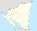
चित्र:Nicaragua location map.svg

Size of this PNG preview of this SVG file: ७०४ × ५९९ पिक्सेल. इतर resolutions: २८२ × २४० पिक्सेल | ५६४ × ४८० पिक्सेल | ९०२ × ७६८ पिक्सेल | १,२०३ × १,०२४ पिक्सेल | २,४०५ × २,०४८ पिक्सेल | १,४०० × १,१९२ पिक्सेल.
मूळ संचिका (SVG संचिका, साधारणपणे १,४०० × १,१९२ pixels, संचिकेचा आकार: १९२ कि.बा.)
संचिकेचा इतिहास
संचिकेची त्यावेळची आवृत्ती बघण्यासाठी त्या दिनांक/वेळेवर टिचकी द्या.
| दिनांक/वेळ | छोटे चित्र | आकार | सदस्य | प्रतिक्रीया | |
|---|---|---|---|---|---|
| सद्य | १२:०६, २५ मे २०२१ |  | १,४०० × १,१९२ (१९२ कि.बा.) | Milenioscuro | corrected some errors |
| १२:००, २५ मे २०२१ |  | १,४०० × १,१९२ (१९२ कि.बा.) | Milenioscuro | corrected department boundaries | |
| ०३:३९, १८ फेब्रुवारी २०१० |  | १,४०० × १,१९२ (४१६ कि.बा.) | Alexrk2 | - | |
| ०१:४२, १७ फेब्रुवारी २०१० |  | १,४०० × १,१९२ (४१५ कि.बा.) | Alexrk2 | == Summary == {{Information |Description= {{de|Positionskarte Nicaragua mit Departamentos, Quadratische Plattkarte, N-S-Streckung 100 %. Geographische Begrenzung der Karte:}} {{en|Location map Nicaragua with Departament |
दुवे
खालील पाने या संचिकेला जोडली आहेत:
जागतिक संचिका उपयोग
संचिकाचे इतर विकिपीडियावरील वापरः
- af.wikipedia.org वरील उपयोग
- an.wikipedia.org वरील उपयोग
- ar.wikipedia.org वरील उपयोग
- ast.wikipedia.org वरील उपयोग
- Greytown (Nicaragua)
- Zapatera (volcán)
- Managua
- Matiguás
- Muy Muy
- Llagu Apanás
- Módulu:Mapa de llocalización/datos/Nicaragua
- Módulu:Mapa de llocalización/datos/Nicaragua/usu
- Aeropuertu Bonanza
- Aeropuertu Punta Huete
- Aeropuertu de Chinandega
- Aeropuertu de Juigalpa
- Aeropuertu de Los Brasiles
- Aeropuertu de Montelimar
- Aeropuertu de Nueva Guinea
- Aeropuertu d'Ometepe
- Aeropuertu de Rosita
- Aeropuertu de San Juan de Nicaragua
- Aeropuertu de Siuna
- Aeropuertu de Waspán
- Aeropuertu internacional Costa Esmeralda
- San Isidro (Nicaragua)
- ba.wikipedia.org वरील उपयोग
- be-tarask.wikipedia.org वरील उपयोग
- be.wikipedia.org वरील उपयोग
- bg.wikipedia.org वरील उपयोग
- bh.wikipedia.org वरील उपयोग
- bn.wikipedia.org वरील उपयोग
या संचिकेचे अधिक वैश्विक उपयोग पहा


