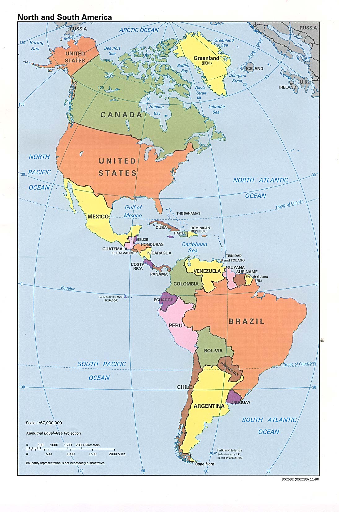
चित्र:N&SAmerica-pol.jpg
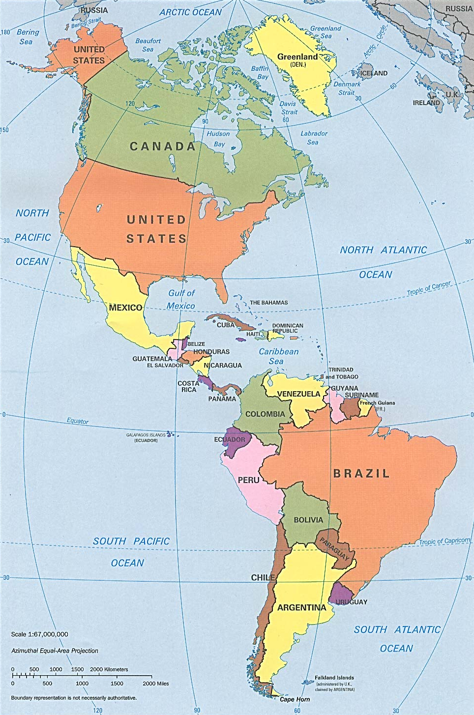
या झलकेचा आकार: ३९७ × ५९९ पिक्सेल पिक्सेल. इतर resolutions: १५९ × २४० पिक्सेल | ३१८ × ४८० पिक्सेल | ९६४ × १,४५५ पिक्सेल.
मूळ संचिका (९६४ × १,४५५ पिक्सेल, संचिकेचा आकार: १.३२ मे.बा., MIME प्रकार: image/jpeg)
सारांश
| वर्णन | Americas with political boundaries |
| दिनांक | |
| स्रोत | http://www.lib.utexas.edu/maps/americas/americas_pol96.jpg |
| लेखक | CIA, original political map from Perry-Castañeda Library Map Collection; University of Texas Library Online |
परवाना:
| This image is a work of a Central Intelligence Agency employee, taken or made as part of that person's official duties. As a Work of the United States Government, this image or media is in the public domain in the United States.
|

|
संचिकेचा इतिहास
संचिकेची त्यावेळची आवृत्ती बघण्यासाठी त्या दिनांक/वेळेवर टिचकी द्या.
| दिनांक/वेळ | छोटे चित्र | आकार | सदस्य | प्रतिक्रीया | |
|---|---|---|---|---|---|
| सद्य | १४:५६, २२ जानेवारी २०२३ | | ९६४ × १,४५५ (१.३२ मे.बा.) | Lojwe | Cropped 1 % horizontally, < 1 % vertically using CropTool with precise mode. |
| २२:२१, १२ जुलै २०१२ |  | ९७० × १,४६० (१.२९ मे.बा.) | McZusatz | cropped (used source file) | |
| ०२:०८, ११ जानेवारी २०१० |  | १,००० × १,५२१ (२८६ कि.बा.) | Entheta | cropped | |
| ००:०२, २६ मार्च २००७ |  | १,०९४ × १,६५० (२८९ कि.बा.) | Corticopious | North and South America: political map (CIA) |
दुवे
खालील पाने या संचिकेला जोडली आहेत:
जागतिक संचिका उपयोग
संचिकाचे इतर विकिपीडियावरील वापरः
- an.wikipedia.org वरील उपयोग
- ar.wikipedia.org वरील उपयोग
- as.wikipedia.org वरील उपयोग
- az.wikipedia.org वरील उपयोग
- az.wiktionary.org वरील उपयोग
- ba.wikipedia.org वरील उपयोग
- ceb.wikipedia.org वरील उपयोग
- el.wikipedia.org वरील उपयोग
- en.wikipedia.org वरील उपयोग
- es.wikipedia.org वरील उपयोग
- es.wikiversity.org वरील उपयोग
- fa.wikipedia.org वरील उपयोग
- fi.wikipedia.org वरील उपयोग
- fr.wikipedia.org वरील उपयोग
- fr.wiktionary.org वरील उपयोग
- fy.wikipedia.org वरील उपयोग
- he.wikipedia.org वरील उपयोग
- hi.wikipedia.org वरील उपयोग
- hy.wikipedia.org वरील उपयोग
- id.wikipedia.org वरील उपयोग
- ig.wikipedia.org वरील उपयोग
- ik.wikipedia.org वरील उपयोग
- inh.wikipedia.org वरील उपयोग
- it.wikipedia.org वरील उपयोग
- ka.wikipedia.org वरील उपयोग
- kcg.wikipedia.org वरील उपयोग
- kk.wikipedia.org वरील उपयोग
- km.wikipedia.org वरील उपयोग
- kn.wikipedia.org वरील उपयोग
- ko.wikipedia.org वरील उपयोग
- la.wikipedia.org वरील उपयोग
- lo.wikipedia.org वरील उपयोग
- mk.wikipedia.org वरील उपयोग
- ml.wikipedia.org वरील उपयोग
- mn.wikipedia.org वरील उपयोग
- nds-nl.wikipedia.org वरील उपयोग
- nl.wikipedia.org वरील उपयोग
- no.wikipedia.org वरील उपयोग
- pcd.wikipedia.org वरील उपयोग
- pt.wikipedia.org वरील उपयोग
- ru.wikipedia.org वरील उपयोग
या संचिकेचे अधिक वैश्विक उपयोग पहा