चित्र:Montserrat-CIA WFB Map.png
यापेक्षा मोठे चित्र उपलब्ध नाही.
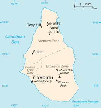
Montserrat-CIA_WFB_Map.png (३२६ × ३४९ पिक्सेल, संचिकेचा आकार: ७ कि.बा., MIME प्रकार: image/png)
This image is in the public domain because it contains materials that originally came from the United States Central Intelligence Agency's World Factbook.
|
 |

|
This file has been superseded by Montserrat map - CIA World Factbook 2021.jpg. It is recommended to use the other file. Please note that deleting superseded images requires consent.
|

|
संचिकेचा इतिहास
संचिकेची त्यावेळची आवृत्ती बघण्यासाठी त्या दिनांक/वेळेवर टिचकी द्या.
| दिनांक/वेळ | छोटे चित्र | आकार | सदस्य | प्रतिक्रीया | |
|---|---|---|---|---|---|
| सद्य | १९:१५, २५ ऑक्टोबर २०२१ | | ३२६ × ३४९ (७ कि.बा.) | Lojwe | Cropped 1 % horizontally, 1 % vertically using CropTool with precise mode. |
| १४:२८, ३० जानेवारी २००६ |  | ३२८ × ३५२ (८ कि.बा.) | Hoshie | Updated map of Montserrat from the CIA World Factbook, 10 Jan 06 rev: http://www.cia.gov/cia/publications/factbook/maps/mh-map.gif | |
| १४:४६, २७ मार्च २००५ |  | ३३० × ३५४ (५ कि.बा.) | Wolfman~commonswiki | {{CIA-map}} |
दुवे
खालील पाने या संचिकेला जोडली आहेत:
जागतिक संचिका उपयोग
संचिकाचे इतर विकिपीडियावरील वापरः
- af.wikipedia.org वरील उपयोग
- diq.wikipedia.org वरील उपयोग
- en.wikisource.org वरील उपयोग
- eu.wikipedia.org वरील उपयोग
- fr.wikipedia.org वरील उपयोग
- hu.wikipedia.org वरील उपयोग
- jv.wikipedia.org वरील उपयोग
- kk.wikipedia.org वरील उपयोग
- pl.wiktionary.org वरील उपयोग
- ru.wikipedia.org वरील उपयोग
- ru.wikivoyage.org वरील उपयोग
- ta.wikipedia.org वरील उपयोग
- tr.wiktionary.org वरील उपयोग
- uk.wikipedia.org वरील उपयोग