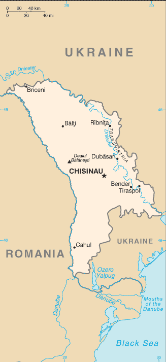
चित्र:Moldova-CIA WFB Map.png
या झलकेचा आकार: २७५ × ६०० पिक्सेल पिक्सेल. इतर resolutions: ११० × २४० पिक्सेल | ३२७ × ७१३ पिक्सेल.
मूळ संचिका (३२७ × ७१३ पिक्सेल, संचिकेचा आकार: १४ कि.बा., MIME प्रकार: image/png)
This image is in the public domain because it contains materials that originally came from the United States Central Intelligence Agency's World Factbook.
|
 |
संचिकेचा इतिहास
संचिकेची त्यावेळची आवृत्ती बघण्यासाठी त्या दिनांक/वेळेवर टिचकी द्या.
| दिनांक/वेळ | छोटे चित्र | आकार | सदस्य | प्रतिक्रीया | |
|---|---|---|---|---|---|
| सद्य | १९:४८, ३० एप्रिल २०२२ | | ३२७ × ७१३ (१४ कि.बा.) | Claude Zygiel | Uploaded separately the enriched version following Pinkerton's advice. |
| २१:५९, १५ एप्रिल २०२२ |  | ३२७ × ५८० (१४६ कि.बा.) | Claude Zygiel | Adding useful details to a current geographic map is very different from "manipulating a historical map". Please tolerate this. | |
| १०:०२, २७ सप्टेंबर २०२१ |  | ३२७ × ७१३ (१४ कि.बा.) | GPinkerton | Reverted to version as of 09:16, 27 March 2005 (UTC) COM:CROP, manipulation of historical document | |
| ००:०८, १० जुलै २०२० |  | ३२७ × ६६२ (३४ कि.बा.) | Claude Zygiel | Development and Autonomous Regions & Extreme Points (red) | |
| १४:४६, २७ मार्च २००५ |  | ३२७ × ७१३ (१४ कि.बा.) | Wolfman~commonswiki | {{CIA-map}} |
दुवे
खालील पाने या संचिकेला जोडली आहेत:
जागतिक संचिका उपयोग
संचिकाचे इतर विकिपीडियावरील वापरः
- be-tarask.wikipedia.org वरील उपयोग
- ca.wikipedia.org वरील उपयोग
- en.wikipedia.org वरील उपयोग
- en.wikisource.org वरील उपयोग
- fa.wikipedia.org वरील उपयोग
- gom.wikipedia.org वरील उपयोग
- he.wikipedia.org वरील उपयोग
- hu.wikipedia.org वरील उपयोग
- hu.wiktionary.org वरील उपयोग
- sq.wikipedia.org वरील उपयोग
- th.wikipedia.org वरील उपयोग
- tr.wikipedia.org वरील उपयोग
- udm.wikipedia.org वरील उपयोग
- vls.wikipedia.org वरील उपयोग
- www.wikidata.org वरील उपयोग
- zh-min-nan.wikipedia.org वरील उपयोग
- zh.wikipedia.org वरील उपयोग