चित्र:MariEl03.png
यापेक्षा मोठे चित्र उपलब्ध नाही.
MariEl03.png (७९५ × ५११ पिक्सेल, संचिकेचा आकार: ३४ कि.बा., MIME प्रकार: image/png)
सारांश
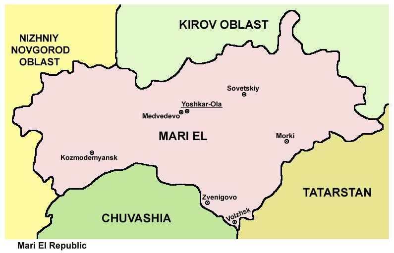
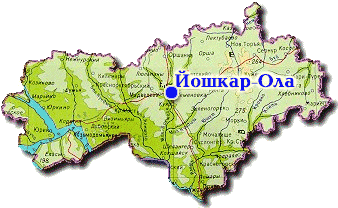
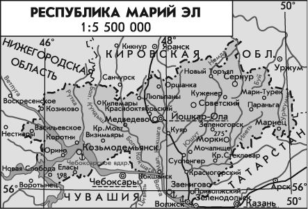
- Map of Mari El Republic.
Source and license

|
This map has been uploaded by Electionworld from en.wikipedia.org to enable the |
Map made by PANONIAN
| This work has been released into the public domain by its author, PANONIAN. This applies worldwide. असे करणे काही देशांमधे कायद्यानुसार शक्य नसू शकते. असे असल्यास : |
References
Maps from external links:
- http://russia-ic.com/img/regions_cities/marii_el1.jpg
- http://www.gertrud-schrenk.de/elena-kerner/mar_img/geografie.jpg
- http://mstecker.com/images/Europe/russia/RusRepMariEl-2_f.jpg
- http://map-site.narod.ru/mariiel-1.jpg
- http://www.zum.de/whkmla/histatlas/russia/mariel.gif
- http://map.rin.ru/maps_e/MariyEl.gif
- http://www.mapzones.com/citymap/russia/republic_of_mari_el/republic_of_mari_el.jpg
- http://www.rdaward.org/map/4s.jpg
- http://russiatrek.org/images/map/mari_el-republic-map.gif
- http://zurich.ru/upload/iblock/3f7/26_mariy_el.gif
- http://trasa.ru/img/regions/mariy-el.gif
- http://www.smsr-senclub.ru/upload/medialibrary/82a/82a5fe53b4e49b37e10594116353cc6f.jpg
- http://worldgeo.ru/rmaps/reg12m.gif
- http://aboutmari.com/css/img_index/mariel_map_big.jpg
- http://www.wapmari.ru/uploads/posts/2008-06/1213119925_mariyelmap.gif
- http://goroder.ru/wp-content/uploads/2011/12/karta_dorog_mary_el.jpg
- http://dic.academic.ru/pictures/enc_geo/Mariy_El.jpg
- http://www.regions.newsall.ru/mariy-el/mariy-el.htm.gif
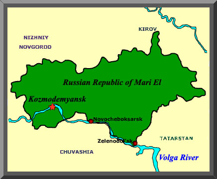
Largest cities and towns in Mari El:
संचिकेचा इतिहास
संचिकेची त्यावेळची आवृत्ती बघण्यासाठी त्या दिनांक/वेळेवर टिचकी द्या.
| दिनांक/वेळ | छोटे चित्र | आकार | सदस्य | प्रतिक्रीया | |
|---|---|---|---|---|---|
| सद्य | १८:३८, २० मे २०१२ | | ७९५ × ५११ (३४ कि.बा.) | PANONIAN | improved version |
| २१:३८, २९ डिसेंबर २००६ |  | ७७३ × ४६९ (१८ कि.बा.) | Electionworld | {{ew|en|PANONIAN}} Map made by PANONIAN {{PD-user|PANONIAN}} Category:Maps of the Russian republics |
दुवे
खालील पाने या संचिकेला जोडली आहेत:
जागतिक संचिका उपयोग
संचिकाचे इतर विकिपीडियावरील वापरः
- ace.wikipedia.org वरील उपयोग
- ast.wikipedia.org वरील उपयोग
- az.wikipedia.org वरील उपयोग
- bg.wikipedia.org वरील उपयोग
- bs.wikipedia.org वरील उपयोग
- ca.wikipedia.org वरील उपयोग
- cs.wikipedia.org वरील उपयोग
- da.wikipedia.org वरील उपयोग
- de.wikipedia.org वरील उपयोग
- en.wikipedia.org वरील उपयोग
- eo.wikipedia.org वरील उपयोग
- es.wikipedia.org वरील उपयोग
- fa.wikipedia.org वरील उपयोग
- fiu-vro.wikipedia.org वरील उपयोग
- frr.wikipedia.org वरील उपयोग
- fr.wikipedia.org वरील उपयोग
- ga.wikipedia.org वरील उपयोग
- hi.wikipedia.org वरील उपयोग
- hu.wikipedia.org वरील उपयोग
- hu.wiktionary.org वरील उपयोग
- id.wikipedia.org वरील उपयोग
- it.wikipedia.org वरील उपयोग
- ja.wikipedia.org वरील उपयोग
- ka.wikipedia.org वरील उपयोग
- ko.wikipedia.org वरील उपयोग
- mk.wikipedia.org वरील उपयोग
- mn.wikipedia.org वरील उपयोग
- ms.wikipedia.org वरील उपयोग
- myv.wikipedia.org वरील उपयोग
- nds.wikipedia.org वरील उपयोग
- nl.wikipedia.org वरील उपयोग
- nn.wikipedia.org वरील उपयोग
- no.wikipedia.org वरील उपयोग
- pl.wikipedia.org वरील उपयोग
- pnb.wikipedia.org वरील उपयोग
- pt.wikipedia.org वरील उपयोग
- ro.wikipedia.org वरील उपयोग
- sco.wikipedia.org वरील उपयोग
- se.wikipedia.org वरील उपयोग
- sh.wikipedia.org वरील उपयोग
- sk.wikipedia.org वरील उपयोग
- sr.wikipedia.org वरील उपयोग
- su.wikipedia.org वरील उपयोग
- sv.wikipedia.org वरील उपयोग
- ta.wikipedia.org वरील उपयोग
- tr.wikipedia.org वरील उपयोग
या संचिकेचे अधिक वैश्विक उपयोग पहा