चित्र:Map of Oregon NA.png

या झलकेचा आकार: ८०० × ५४१ पिक्सेल पिक्सेल. इतर resolutions: ३२० × २१७ पिक्सेल | ६४० × ४३३ पिक्सेल | १,०२४ × ६९३ पिक्सेल | १,२८० × ८६६ पिक्सेल | १,९६७ × १,३३१ पिक्सेल.
मूळ संचिका (१,९६७ × १,३३१ पिक्सेल, संचिकेचा आकार: २.१५ मे.बा., MIME प्रकार: image/png)
सारांश
| वर्णन |
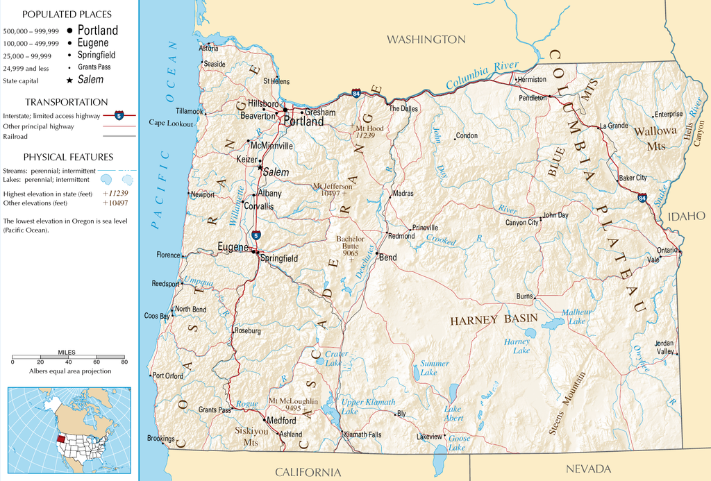
English: Topographic map of the geography of Oregon — with major rivers shown.
|
| स्रोत | National Atlas |
| लेखक | Unknown author |
परवाना:
This map was obtained from an edition of the National Atlas of the United States. Like almost all works of the U.S. federal government, works from the National Atlas are in the public domain in the United States.
Online access: NationalAtlas.gov | 1970 print edition: Library of Congress, Perry-Castañeda Library
|
संचिकेचा इतिहास
संचिकेची त्यावेळची आवृत्ती बघण्यासाठी त्या दिनांक/वेळेवर टिचकी द्या.
| दिनांक/वेळ | छोटे चित्र | आकार | सदस्य | प्रतिक्रीया | |
|---|---|---|---|---|---|
| सद्य | ११:१६, १६ ऑक्टोबर २००७ | | १,९६७ × १,३३१ (२.१५ मे.बा.) | Peteforsyth | removed extraneous text and logo from public domain image |
| १३:४३, १५ ऑगस्ट २००६ |  | २,१२२ × १,६४० (२.७५ मे.बा.) | Huebi~commonswiki | {{Information| |Description=Map of Oregon |Source=[http://www.nationalatlas.gov National Atlas] }} Category:Maps of the United States Category:Maps of Oregon {{PD-USGov-Atlas}} |
दुवे
खालील पाने या संचिकेला जोडली आहेत:
जागतिक संचिका उपयोग
संचिकाचे इतर विकिपीडियावरील वापरः
- als.wikipedia.org वरील उपयोग
- ar.wikipedia.org वरील उपयोग
- de.wikipedia.org वरील उपयोग
- en.wikipedia.org वरील उपयोग
- eo.wikipedia.org वरील उपयोग
- fi.wikipedia.org वरील उपयोग
- fr.wikipedia.org वरील उपयोग
- hr.wiktionary.org वरील उपयोग
- hsb.wikipedia.org वरील उपयोग
- hu.wikipedia.org वरील उपयोग
- incubator.wikimedia.org वरील उपयोग
- is.wikipedia.org वरील उपयोग
- it.wikipedia.org वरील उपयोग
- ja.wikipedia.org वरील उपयोग
- kk.wikipedia.org वरील उपयोग
- lt.wikipedia.org वरील उपयोग
- nds-nl.wikipedia.org वरील उपयोग
- pa.wikipedia.org वरील उपयोग
- ru.wikipedia.org वरील उपयोग
- sw.wikipedia.org वरील उपयोग
- vi.wikipedia.org वरील उपयोग
- zea.wikipedia.org वरील उपयोग