चित्र:Map PMNM 2016.jpg

या झलकेचा आकार: ८०० × ४४५ पिक्सेल पिक्सेल. इतर resolutions: ३२० × १७८ पिक्सेल | ६४० × ३५६ पिक्सेल | १,२०० × ६६७ पिक्सेल.
मूळ संचिका (१,२०० × ६६७ पिक्सेल, संचिकेचा आकार: २४९ कि.बा., MIME प्रकार: image/jpeg)

|
This map image could be re-created using vector graphics as an SVG file. This has several advantages; see Commons:Media for cleanup for more information. If an SVG form of this image is available, please upload it and afterwards replace this template with
{{vector version available|new image name}}.
It is recommended to name the SVG file “Map PMNM 2016.svg”—then the template Vector version available (or Vva) does not need the new image name parameter. |


सारांश
| वर्णन |
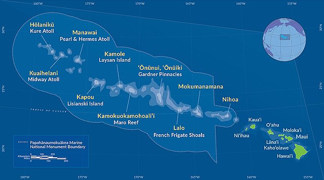
Deutsch: Karte des Papahānaumokuākea Marine National Monument (2016)
English: Map of Papahānaumokuākea Marine National Monument (2016) |
| दिनांक | |
| स्रोत | http://www.papahanaumokuakea.gov/ |
| लेखक | NOAA |
परवाना:
This image is in the public domain because it contains materials that originally came from the U.S. National Oceanic and Atmospheric Administration, taken or made as part of an employee's official duties.
|
संचिकेचा इतिहास
संचिकेची त्यावेळची आवृत्ती बघण्यासाठी त्या दिनांक/वेळेवर टिचकी द्या.
| दिनांक/वेळ | छोटे चित्र | आकार | सदस्य | प्रतिक्रीया | |
|---|---|---|---|---|---|
| सद्य | १४:५९, २८ ऑगस्ट २०१६ | | १,२०० × ६६७ (२४९ कि.बा.) | NordNordWest | == {{int:filedesc}} == {{Information |Description={{de|Karte des Papahānaumokuākea Marine National Monument (2016)}} {{en|Map of [[:en:Papahānaumokuākea Marine National Monument|Papahānaumokuāk... |
दुवे
खालील पाने या संचिकेला जोडली आहेत:
जागतिक संचिका उपयोग
संचिकाचे इतर विकिपीडियावरील वापरः
- de.wikipedia.org वरील उपयोग
- en.wikipedia.org वरील उपयोग
- es.wikipedia.org वरील उपयोग
- fr.wikipedia.org वरील उपयोग
- gl.wikipedia.org वरील उपयोग
- hr.wikipedia.org वरील उपयोग
- id.wikipedia.org वरील उपयोग
- it.wikipedia.org वरील उपयोग
- ja.wikipedia.org वरील उपयोग
- la.wikipedia.org वरील उपयोग
- lt.wikipedia.org वरील उपयोग
- pl.wikipedia.org वरील उपयोग
- sr.wikipedia.org वरील उपयोग
- tr.wikipedia.org वरील उपयोग
- uk.wikipedia.org वरील उपयोग
- vi.wikipedia.org वरील उपयोग
- www.wikidata.org वरील उपयोग
- zh-yue.wikipedia.org वरील उपयोग
- zh.wikipedia.org वरील उपयोग