चित्र:Maharashtra locator map.png

या झलकेचा आकार: ८०० × ५८३ पिक्सेल पिक्सेल. इतर resolutions: ३२० × २३३ पिक्सेल | ६४० × ४६६ पिक्सेल | १,०२४ × ७४६ पिक्सेल | १,२८० × ९३३ पिक्सेल | २,५६० × १,८६६ पिक्सेल | ३,०९७ × २,२५७ पिक्सेल.
मूळ संचिका (३,०९७ × २,२५७ पिक्सेल, संचिकेचा आकार: ८७८ कि.बा., MIME प्रकार: image/png)
वर्णन संपादन
| वर्णन |
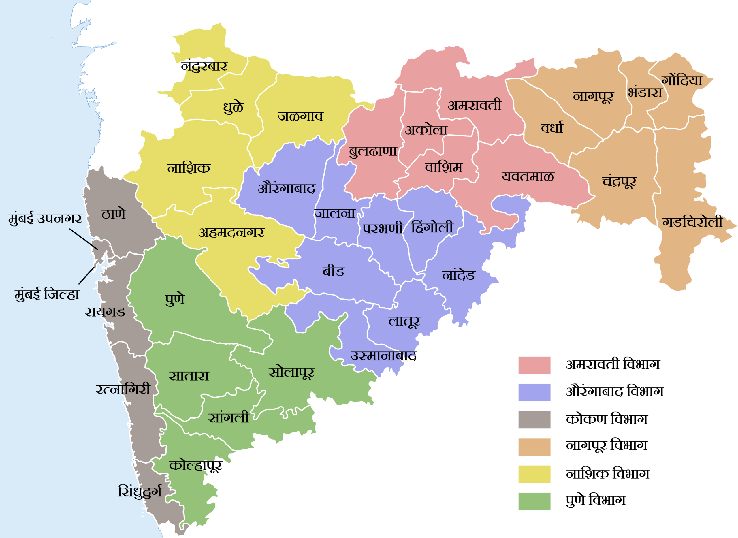
महाराष्ट्रातील प्रशासकीय विभाग आणि जिल्हे |
| दिनांक | (UTC) |
| स्रोत | |
| लेखक |
|
परवाना: संपादन
I, the copyright holder of this work, hereby publish it under the following license:
|
| This file is now available on Wikimedia Commons as File:Maharashtra locator map.png (with the same name). Files that have been tagged with this template may be deleted after satisfying conditions of CSD F8. Administrators: If the file has been properly moved, delete it. If not, change the {{Now Commons}} tag to: {{Not moved to Commons|Maharashtra locator map.png|reason=reason why the image could not be moved}}
|
संचिकेचा इतिहास
संचिकेची त्यावेळची आवृत्ती बघण्यासाठी त्या दिनांक/वेळेवर टिचकी द्या.
| दिनांक/वेळ | छोटे चित्र | आकार | सदस्य | प्रतिक्रीया | |
|---|---|---|---|---|---|
| सद्य | २३:५७, १६ ऑगस्ट २०११ | | ३,०९७ × २,२५७ (८७८ कि.बा.) | Kaajawa (चर्चा | योगदान) | Source:File:Maharashtra locator map.svg License: CC-SA 3.0 |
या संचिकेवर आपण पुनर्लिखाण करू शकत नाही.
दुवे
खालील संचिका या दिलेल्या संचिकेची प्रत आहे. अधिक माहिती
- चित्र:Maharashtra locator map.png Wikimedia Commons पासून
या चित्राशी जोडलेली पृष्ठे नाहीत.