चित्र:LAX Airport Diagram.svg

Size of this PNG preview of this SVG file: ३७८ × ५५२ पिक्सेल. इतर resolutions: १६४ × २४० पिक्सेल | ३२९ × ४८० पिक्सेल | ५२६ × ७६८ पिक्सेल | ७०१ × १,०२४ पिक्सेल | १,४०२ × २,०४८ पिक्सेल.
मूळ संचिका (SVG संचिका, साधारणपणे ३७८ × ५५२ pixels, संचिकेचा आकार: १.०९ मे.बा.)
सारांश
| वर्णन |
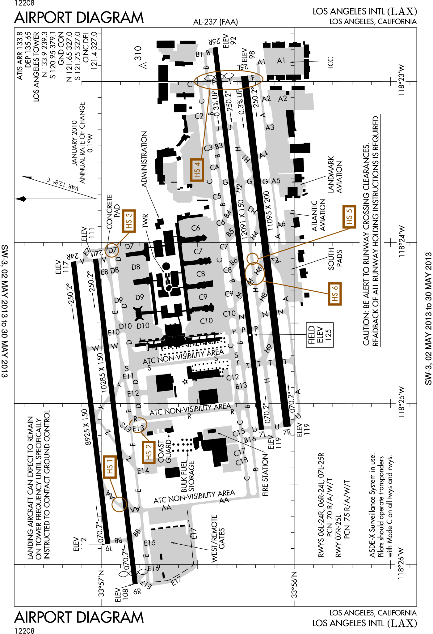
English: FAA Airport Diagram of Los Angeles International Airport. |
| दिनांक | |
| स्रोत |
FAA Airport Diagrams; note that these change every 28 days. Taken from PDF on FAA site and converted to SVG using en:Wikipedia:How to draw SVG circuits using Xcircuit. |
| लेखक | Produced by the National Aeronautical Charting Office (NACO), a department of the United States en:Federal Aviation Administration. |
| Camera location | | View this and other nearby images on: OpenStreetMap |
|---|
W3C-validity not checked.
परवाना:
This image or file is a work of a Federal Aviation Administration employee, taken or made as part of that person's official duties. As a work of the U.S. federal government, the image is in the public domain in the United States.
|
 |
संचिकेचा इतिहास
संचिकेची त्यावेळची आवृत्ती बघण्यासाठी त्या दिनांक/वेळेवर टिचकी द्या.
| दिनांक/वेळ | छोटे चित्र | आकार | सदस्य | प्रतिक्रीया | |
|---|---|---|---|---|---|
| सद्य | १९:५२, २ मे २०१३ | | ३७८ × ५५२ (१.०९ मे.बा.) | Grendelkhan | SVG version of FAA's PDF diagram. |
दुवे
खालील पाने या संचिकेला जोडली आहेत:
जागतिक संचिका उपयोग
संचिकाचे इतर विकिपीडियावरील वापरः
- ca.wikipedia.org वरील उपयोग
- cs.wikipedia.org वरील उपयोग
- da.wikipedia.org वरील उपयोग
- de.wikipedia.org वरील उपयोग
- it.wikipedia.org वरील उपयोग
- www.wikidata.org वरील उपयोग