चित्र:Kocaeli districts.png
यापेक्षा मोठे चित्र उपलब्ध नाही.
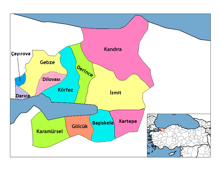
Kocaeli_districts.png (७७६ × ६०० पिक्सेल, संचिकेचा आकार: १२८ कि.बा., MIME प्रकार: image/png)
सारांश
| वर्णन | Map of the districts of Kocaeli province in Turkey. Created by Rarelibra 22:01, 1 December 2006 (UTC) for public domain use, using MapInfo Professional v8.5 and various mapping resources. Edited by One Homo Sapiens Corrected text where İ,Ş,ı,ğ,or ş occurs in name. Source: [statoids-com]. Increased font size and enhanced color differences among adjacent districts. |
| दिनांक | डिसेंबर १, इ.स. २००६ (original upload date) |
| स्रोत | No machine-readable source provided. Own work assumed (based on copyright claims). |
| लेखक | No machine-readable author provided. Rarelibra assumed (based on copyright claims). |
परवाना:
| I, the copyright holder of this work, release this work into the public domain. This applies worldwide. असे करणे काही देशांमधे कायद्यानुसार शक्य नसू शकते. असे असल्यास : मी कोणालाही कोणत्याही कारणासाठी हे काम वापरण्याचे अधिकार कोणत्याही बंधनाशिवाय जर अशी बंधने कायद्याने बंधनकारक नसतीलतर देत आहोत. |
संचिकेचा इतिहास
संचिकेची त्यावेळची आवृत्ती बघण्यासाठी त्या दिनांक/वेळेवर टिचकी द्या.
| दिनांक/वेळ | छोटे चित्र | आकार | सदस्य | प्रतिक्रीया | |
|---|---|---|---|---|---|
| सद्य | १७:२८, ११ डिसेंबर २०१८ | | ७७६ × ६०० (१२८ कि.बा.) | Surprizi | Updated/corrected map. |
| ०१:५५, २९ फेब्रुवारी २०१२ |  | ४६९ × ४०३ (३८ कि.बा.) | Sadrettin | Reverted to version as of 09:02, 31 August 2009 | |
| १५:२४, २६ फेब्रुवारी २०१२ |  | ७७६ × ६०० (१२१ कि.बा.) | Nanahuatl | Reverted to version as of 13:17, 17 June 2009 | |
| १४:३२, ३१ ऑगस्ट २००९ |  | ४६९ × ४०३ (३८ कि.बा.) | Krofesyonel | {{Information |Description=Kocaeli'nin doğru haritası, kendi çalışmamdır. |Source=Kendi çalışmam |Date=31 August 2009, Monday (''31 Ağustos 2009, Pazartesi'') |Author=User:Krofesyonel |Permission= |other_versions= }} | |
| १८:४७, १७ जून २००९ |  | ७७६ × ६०० (१२१ कि.बा.) | Argymeg | Reverted to version as of 19:23, 7 April 2009 | |
| ००:५४, ८ एप्रिल २००९ |  | १,०५६ × ८१६ (२६ कि.बा.) | Derinkaya | Reverted to version as of 01:23, 29 December 2008 | |
| ००:५३, ८ एप्रिल २००९ |  | ७७६ × ६०० (१२१ कि.बा.) | Derinkaya | {{Information |Description=Map of the districts of Kocaeli province in Turkey. Created by Rarelibra 22:01, 1 December 2006 (UTC) for public domain use, using MapInfo Professional v8.5 and various mapping resources. Edited by [[User:One | |
| ०६:५३, २९ डिसेंबर २००८ |  | १,०५६ × ८१६ (२६ कि.बा.) | One Homo Sapiens | Corrected text where İ,Ş,ı,ğ,or ş occurs in name. Source: [statoids-com]. Increased font size and enhanced color differences among adjacent districts. | |
| २१:२८, १२ एप्रिल २००७ |  | ७७६ × ६०० (९६ कि.बा.) | KureCewlik81 | ||
| १९:४५, २० फेब्रुवारी २००७ |  | १,०५६ × ८१६ (२७ कि.बा.) | Rarelibra | Updated/corrected map. |
दुवे
खालील पाने या संचिकेला जोडली आहेत:
जागतिक संचिका उपयोग
संचिकाचे इतर विकिपीडियावरील वापरः
- azb.wikipedia.org वरील उपयोग
- az.wikipedia.org वरील उपयोग
- ba.wikipedia.org वरील उपयोग
- diq.wikipedia.org वरील उपयोग
- en.wikipedia.org वरील उपयोग
- en.wiktionary.org वरील उपयोग
- eo.wikipedia.org वरील उपयोग
- eu.wikipedia.org वरील उपयोग
- fa.wikipedia.org वरील उपयोग
- fi.wikipedia.org वरील उपयोग
- fo.wikipedia.org वरील उपयोग
- fr.wikipedia.org वरील उपयोग
- hy.wikipedia.org वरील उपयोग
या संचिकेचे अधिक वैश्विक उपयोग पहा