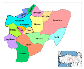
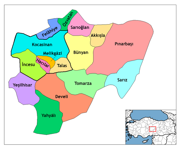
चित्र:Kayseri districts.png

या झलकेचा आकार: ७२९ × ६०० पिक्सेल पिक्सेल. इतर resolutions: २९२ × २४० पिक्सेल | ५८३ × ४८० पिक्सेल | ९९९ × ८२२ पिक्सेल.
मूळ संचिका (९९९ × ८२२ पिक्सेल, संचिकेचा आकार: ५१ कि.बा., MIME प्रकार: image/png)
सारांश
| वर्णन | Map of the districts of Kayseri province in Turkey. Created by Rarelibra 21:59, 1 December 2006 (UTC) for public domain use, using MapInfo Professional v8.5 and various mapping resources. Edited by One Homo Sapiens Corrected text where İ, Ş, ı, ğ, or ş occurs in name. Source: [statoids-com]. Increased font size and enhanced color differences among adjacent districts. User:Sae1962 Marked the boundaries of the provincial centre, the city of Kayseri, with bold lines. |
| दिनांक | डिसेंबर १, इ.स. २००६ (original upload date) |
| स्रोत | No machine-readable source provided. Own work assumed (based on copyright claims). |
| लेखक | No machine-readable author provided. Rarelibra assumed (based on copyright claims). |
परवाना:
| I, the copyright holder of this work, release this work into the public domain. This applies worldwide. असे करणे काही देशांमधे कायद्यानुसार शक्य नसू शकते. असे असल्यास : मी कोणालाही कोणत्याही कारणासाठी हे काम वापरण्याचे अधिकार कोणत्याही बंधनाशिवाय जर अशी बंधने कायद्याने बंधनकारक नसतीलतर देत आहोत. |
संचिकेचा इतिहास
संचिकेची त्यावेळची आवृत्ती बघण्यासाठी त्या दिनांक/वेळेवर टिचकी द्या.
| दिनांक/वेळ | छोटे चित्र | आकार | सदस्य | प्रतिक्रीया | |
|---|---|---|---|---|---|
| सद्य | १६:५५, ३० जुलै २००९ | | ९९९ × ८२२ (५१ कि.बा.) | Sae1962 | {{Information |Description=Map of the districts of Kayseri province in Turkey. Created by Rarelibra 21:59, 1 December 2006 (UTC) for public domain use, using MapInfo Professional v8.5 and various mapping resources. Edited by [[User:One |
| १३:५४, ४ मे २००९ |  | ९९९ × ८२२ (५० कि.बा.) | Sae1962 | Added long vowels for better reading. | |
| ०५:२४, २९ डिसेंबर २००८ |  | १,०५६ × ८१६ (३५ कि.बा.) | One Homo Sapiens | Corrected text where İ,Ş,ı,ğ,or ş occurs in name. Source: [statoids-com]. Increased font size and enhanced color differences among adjacent districts. | |
| ०३:२९, २ डिसेंबर २००६ |  | १,०५६ × ८१६ (३३ कि.बा.) | Rarelibra | Map of the districts of Kayseri province in Turkey. Created by ~~~~ for public domain use, using MapInfo Professional v8.5 and various mapping resources. |
दुवे
खालील पाने या संचिकेला जोडली आहेत:
जागतिक संचिका उपयोग
संचिकाचे इतर विकिपीडियावरील वापरः
- ast.wikipedia.org वरील उपयोग
- az.wikipedia.org वरील उपयोग
- be.wikipedia.org वरील उपयोग
- ca.wikipedia.org वरील उपयोग
- cs.wikipedia.org वरील उपयोग
- de.wikipedia.org वरील उपयोग
- Kayseri
- Talas (Kayseri)
- Yahyalı
- Hacılar (Kayseri)
- Talas (Bezirk)
- Tomarza
- Wikipedia:Kartenwerkstatt/Archiv/2011-01
- Wikipedia:Kartenwerkstatt/Archiv/2011-05
- Develi (Kayseri)
- Vorlage:Navigationsleiste Landkreise der Provinz Kayseri
- Akkışla
- Bünyan
- Felahiye
- İncesu (Kayseri)
- Kocasinan
- Melikgazi
- Özvatan
- Pınarbaşı (Kayseri)
- Sarıoğlan
- Sarız
- Yeşilhisar (Kayseri)
- diq.wikipedia.org वरील उपयोग
- en.wikipedia.org वरील उपयोग
या संचिकेचे अधिक वैश्विक उपयोग पहा