चित्र:Karta FP Societe isl.PNG
यापेक्षा मोठे चित्र उपलब्ध नाही.
Karta_FP_Societe_isl.PNG (४५० × ४०० पिक्सेल, संचिकेचा आकार: ६ कि.बा., MIME प्रकार: image/png)
सारांश
| वर्णन |
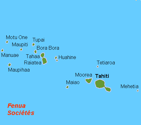
Deutsch: Karte der Gesellschaftsinseln, Französisch Polynesien
English: Map (rough) of the Society Islands, French Polynesia, own work composed from various mapreferences
Svenska: Karta över Sällskapsöarna, Franska Polynesien |
| दिनांक | |
| स्रोत | स्वतःचे काम |
| लेखक | Hobe / Holger Behr |
परवाना:
| I, the copyright holder of this work, release this work into the public domain. This applies worldwide. असे करणे काही देशांमधे कायद्यानुसार शक्य नसू शकते. असे असल्यास : मी कोणालाही कोणत्याही कारणासाठी हे काम वापरण्याचे अधिकार कोणत्याही बंधनाशिवाय जर अशी बंधने कायद्याने बंधनकारक नसतीलतर देत आहोत. |

|
This locator map image could be re-created using vector graphics as an SVG file. This has several advantages; see Commons:Media for cleanup for more information. If an SVG form of this image is available, please upload it and afterwards replace this template with
{{vector version available|new image name}}.
It is recommended to name the SVG file “Karta FP Societe isl.svg”—then the template Vector version available (or Vva) does not need the new image name parameter. |
संचिकेचा इतिहास
संचिकेची त्यावेळची आवृत्ती बघण्यासाठी त्या दिनांक/वेळेवर टिचकी द्या.
| दिनांक/वेळ | छोटे चित्र | आकार | सदस्य | प्रतिक्रीया | |
|---|---|---|---|---|---|
| सद्य | १८:३८, २१ एप्रिल २००७ | | ४५० × ४०० (६ कि.बा.) | Hobe | karta Societeisl FP, Holger Behr, own work |
दुवे
खालील पाने या संचिकेला जोडली आहेत:
जागतिक संचिका उपयोग
संचिकाचे इतर विकिपीडियावरील वापरः
- af.wikipedia.org वरील उपयोग
- ar.wikipedia.org वरील उपयोग
- bg.wikipedia.org वरील उपयोग
- bn.wikipedia.org वरील उपयोग
- br.wikipedia.org वरील उपयोग
- ca.wikipedia.org वरील उपयोग
- ckb.wikipedia.org वरील उपयोग
- cs.wikipedia.org वरील उपयोग
- da.wikipedia.org वरील उपयोग
- de.wikipedia.org वरील उपयोग
- de.wikivoyage.org वरील उपयोग
- el.wikipedia.org वरील उपयोग
- en.wikipedia.org वरील उपयोग
- Raiatea
- Tetiꞌaroa
- Windward Islands (Society Islands)
- Maupiti
- Motu One (Society Islands)
- Society Islands
- Maiao
- Maupihaa
- Mehetia
- Wikipedia:Graphics Lab/Map workshop/Archive/Dec 2011
- Wikipedia:Graphics Lab/Map workshop/Archive/May 2012
- Wikipedia:Graphics Lab/Map workshop/Archive/Jul 2012
- The Brando Resort
- Society Islands tropical moist forests
- eo.wikipedia.org वरील उपयोग
या संचिकेचे अधिक वैश्विक उपयोग पहा