चित्र:Irish Sea satellite image.jpg
यापेक्षा मोठे चित्र उपलब्ध नाही.
Irish_Sea_satellite_image.jpg (४३६ × ५७६ पिक्सेल, संचिकेचा आकार: ५४ कि.बा., MIME प्रकार: image/jpeg)
सारांश
| वर्णन |
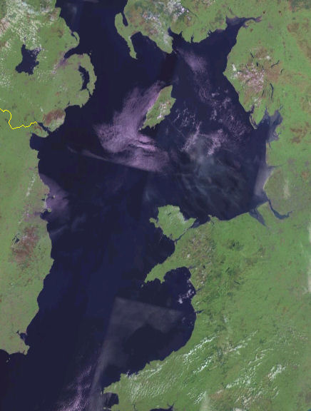
English: Satellite image of the Irish Sea from the NASA Blue Marble project.
Español: Mapa del Mar de Irlanda en el proyecto Blue Marble de la NASA. |
| दिनांक | जून १५, इ.स. २०१२, १९:४९ (UTC) (upload date) |
| स्रोत |
This file was derived from: Irish Sea 4.82844W 53.54821N.png: |
| लेखक |
|
| This is a retouched picture, which means that it has been digitally altered from its original version. Modifications: Cropped. The original can be viewed here: Irish Sea 4.82844W 53.54821N.png:
|
परवाना:
| This image is in the public domain because it is a screenshot from NASA’s globe software World Wind using a public domain layer, such as Blue Marble, MODIS, Landsat, SRTM, USGS or GLOBE.
|
 |
चढवल्याचे मुळ विवरण
This image is a derivative work of the following images:
- File:Irish_Sea_4.82844W_53.54821N.png licensed with PD-WorldWind
- 2005-05-20T19:09:05Z Jelte 992x653 (934277 Bytes) NASA [[World-Wind]] screenshot. {{PD-USGov-NASA}}
Uploaded with derivativeFX
संचिकेचा इतिहास
संचिकेची त्यावेळची आवृत्ती बघण्यासाठी त्या दिनांक/वेळेवर टिचकी द्या.
| दिनांक/वेळ | छोटे चित्र | आकार | सदस्य | प्रतिक्रीया | |
|---|---|---|---|---|---|
| सद्य | ०१:२४, १६ जून २०१२ | | ४३६ × ५७६ (५४ कि.बा.) | Dr Greg | == {{int:filedesc}} == {{Information |Description={{en|Satellite image of the en:Irish Sea from the NASA Blue Marble project.}} {{es|Mapa del es:Mar de Irlanda en el proyecto Blue Marble de la NASA.}} |Source={{Derived from|Irish_Sea_4.8284... |
दुवे
खालील पाने या संचिकेला जोडली आहेत:
जागतिक संचिका उपयोग
संचिकाचे इतर विकिपीडियावरील वापरः
- af.wikipedia.org वरील उपयोग
- azb.wikipedia.org वरील उपयोग
- bh.wikipedia.org वरील उपयोग
- ckb.wikipedia.org वरील उपयोग
- de.wikipedia.org वरील उपयोग
- el.wikipedia.org वरील उपयोग
- en.wikipedia.org वरील उपयोग
- fi.wikipedia.org वरील उपयोग
- frr.wikipedia.org वरील उपयोग
- he.wikipedia.org वरील उपयोग
- hu.wikipedia.org वरील उपयोग
- kk.wikipedia.org वरील उपयोग
- la.wikipedia.org वरील उपयोग
- pl.wikipedia.org वरील उपयोग
- pnb.wikipedia.org वरील उपयोग
- rue.wikipedia.org वरील उपयोग
- sr.wikipedia.org वरील उपयोग
- sv.wikipedia.org वरील उपयोग
- th.wikipedia.org वरील उपयोग
- uk.wikipedia.org वरील उपयोग
- vi.wikipedia.org वरील उपयोग