मूळ संचिका(५७५ × ७९२ पिक्सेल, संचिकेचा आकार: ३१ कि.बा., MIME प्रकार: image/gif)

ही संचिका Wikimedia Commons येथील असून ती इतर प्रकल्पात वापरलेली असू शकते. तिचे तेथील संचिका वर्णन पान खाली दाखवले आहे.

This map image could be re-created using vector graphics as an SVG file. This has several advantages; see Commons:Media for cleanup for more information. If an SVG form of this image is available, please upload it and afterwards replace this template with {{vector version available|new image name}}.


It is recommended to name the SVG file “First century Iudaea province.svg”—then the template Vector version available (or Vva) does not need the new image name parameter.

सारांश

वर्णन
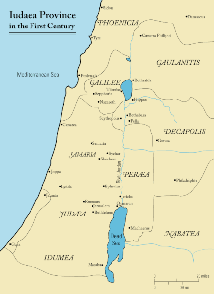
English: This is a map of first century Iudaea Province that I created using Illustrator CS2. I traced this image for the general geographic features. I then manually input data from maps found in a couple of sources.
  • Robert W. Funk and the Jesus Seminar. The Acts of Jesus. HarperSanFrancisco: 1998. p. xxiv.
  • Michael Grant. Jesus: An Historian's Review of the Gospels. Charles Scribner's Sons: 1977. p. 65-67.
  • John P. Meier. A Marginal Jew. Doubleday: 1991. p. 1:434.
दिनांक मार्च २३, इ.स. २००६ (original upload date)
स्रोत ने en.wikipedia पासून कॉमन्सवर हस्तांतरित केले.
लेखक Andrew c at इंग्रजी विकिपीडिया
परवानगी
(या संचिकेचा पुनर्वापर करीत आहे)
Released under the GNU Free Documentation License or CC-BY.
इतर आवृत्तींस العربيَّة

परवाना:

Andrew c from en.wikipedia.org, the copyright holder of this work, hereby publishes it under the following license:
GNU head फ्री सॉफ्टवेअर फाऊंडेशन द्वारे प्रकाशित जीएनयू मुक्त दस्ताऐवजीकरण परवाना, आवृत्ती १.२ किंवा त्यानंतरची,या अंतर्गत; या दस्तावेजास, नकलविण्याची, वितरणाची व/किंवा फेरबदलाची परवानगी दिल्या जाते या अटींसह कि त्यात कोणतेही निश्चलित(Invariant) विभाग नकोत,पृष्टपान मजकूर नको व मलपान मजकूर नको. GNU Free Documentation License हा मथळा असलेल्या विभागात,या परवान्याची प्रत अंतर्भूत केलेली आहे. Subject to disclaimers.
w:en:Creative Commons
रोपण
ही संचिका खालील परवान्याअंतर्गत आहे - क्रीएटिव्ह कॉमन्स Attribution 3.0 Unported.
रोपण: Wikipedia User:Andrew c
तुम्ही मुक्त आहात.
  • सामायिक करा – नक्कल, वितरण आणि पारेषित करण्यास
  • पुर्नमिश्रीत करण्यास – काम गरजेनुसार अनुकुलीत करण्यास
खालील अटींच्या अधिन राहून:
  • रोपण – आपण योग्य क्रेडिट देणे आवश्यक आहे, परवान्यास दुवा प्रदान करणे आवश्यक आहे, आणि बदल केले गेले आहेत हे दर्शविणे आवश्यक आहे. आपण हे कोणत्याही वाजवी मार्गाने करू शकता, परंतु परवानाधारक आपल्यास किंवा आपल्या वापरास मान्यता देतो अशा कोणत्याही मार्गाने नाही.
Public domain I, the copyright holder of this work, release this work into the public domain. This applies worldwide.
असे करणे काही देशांमधे कायद्यानुसार शक्य नसू शकते. असे असल्यास :
मी कोणालाही कोणत्याही कारणासाठी हे काम वापरण्याचे अधिकार कोणत्याही बंधनाशिवाय जर अशी बंधने कायद्याने बंधनकारक नसतीलतर देत आहोत.

चढवल्याचे मुळ विवरण

The original description page was here. All following user names refer to en.wikipedia.
  • 2006-03-24 18:48 Andrew c 575×792×8 (32374 bytes) This is a map of First Century Palestine that I created using Illustrator CS2. I traced [http://commons.wikimedia.org/wiki/Image:Map_of_administrative_regions_in_Israel.png this] image for the general geographic features. I then manually input data from m
  • 2006-03-23 19:48 Andrew c 587×790×8 (30752 bytes) This is a map of First Century Palestine that I created using Illustrator CS2. I traced [http://commons.wikimedia.org/wiki/Image:Map_of_administrative_regions_in_Israel.png this] image for the general geographic features. I then manually input data from m

Captions

Add a one-line explanation of what this file represents
Judaea province in the 1st Century CE

Items portrayed in this file

depicts इंग्रजी

copyright status इंग्रजी

२३ मार्च 2006

checksum इंग्रजी

e488e0183049d2138c916ccc7a24c107807f12b7

data size इंग्रजी

३२,०१९ byte

७९२ चित्रपेशी

५७५ चित्रपेशी

संचिकेचा इतिहास

संचिकेची त्यावेळची आवृत्ती बघण्यासाठी त्या दिनांक/वेळेवर टिचकी द्या.

दिनांक/वेळछोटे चित्रआकारसदस्यप्रतिक्रीया
सद्य१७:१७, १८ सप्टेंबर २०१११७:१७, १८ सप्टेंबर २०११ आवृत्तीसाठी छोटे चित्र५७५ × ७९२ (३१ कि.बा.)OnceinawhileRemoved region-name "Philistia", as incorrect
१९:३५, १३ सप्टेंबर २००७१९:३५, १३ सप्टेंबर २००७ आवृत्तीसाठी छोटे चित्र५७५ × ७९२ (३२ कि.बा.)Liftarn{{SVG|map}} {{Information |Description=This is a map of first century en:Iudaea Province that I created using Illustrator CS2. I traced [http://commons.wikimedia.org/wiki/Image:Map_of_administrative_regions_in_Israel.png this] image for the general g
०५:५९, ३० एप्रिल २००६०५:५९, ३० एप्रिल २००६ आवृत्तीसाठी छोटे चित्र५७५ × ७९२ (३२ कि.बा.)Duende~commonswikihttp://en.wikipedia.org/wiki/Image:First_century_palestine.gif

खालील पाने या संचिकेला जोडली आहेत:

जागतिक संचिका उपयोग

संचिकाचे इतर विकिपीडियावरील वापरः

या संचिकेचे अधिक वैश्विक उपयोग पहा