चित्र:British Islands.svg

Size of this PNG preview of this SVG file: ३४३ × ६०० पिक्सेल. इतर resolutions: १३७ × २४० पिक्सेल | २७४ × ४८० पिक्सेल | ४३९ × ७६८ पिक्सेल | ५८६ × १,०२४ पिक्सेल | १,१७१ × २,०४८ पिक्सेल | ६७५ × १,१८० पिक्सेल.
मूळ संचिका (SVG संचिका, साधारणपणे ६७५ × १,१८० pixels, संचिकेचा आकार: २४३ कि.बा.)
सारांश
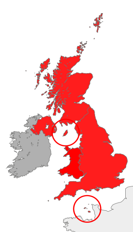
| वर्णन | map showing the territory referred to as "the British Islands" in relation to Great Britain and Ireland (namely the United Kingdom plus the Crown Dependencies, but not the Republic of Ireland) |
| दिनांक | |
| स्रोत | स्वतःचे काम |
| लेखक | Cnbrb |
| SVG genesis |
परवाना:
| I, the copyright holder of this work, release this work into the public domain. This applies worldwide. असे करणे काही देशांमधे कायद्यानुसार शक्य नसू शकते. असे असल्यास : मी कोणालाही कोणत्याही कारणासाठी हे काम वापरण्याचे अधिकार कोणत्याही बंधनाशिवाय जर अशी बंधने कायद्याने बंधनकारक नसतीलतर देत आहोत. |
संचिकेचा इतिहास
संचिकेची त्यावेळची आवृत्ती बघण्यासाठी त्या दिनांक/वेळेवर टिचकी द्या.
| दिनांक/वेळ | छोटे चित्र | आकार | सदस्य | प्रतिक्रीया | |
|---|---|---|---|---|---|
| सद्य | १८:१५, २८ ऑक्टोबर २०१६ | | ६७५ × १,१८० (२४३ कि.बा.) | Smyth | Highlight crown dependencies, otherwise map looks identical to File:British Isles United Kingdom.svg at small sizes. |
| ०३:०२, २१ ऑक्टोबर २००७ |  | ६७५ × १,१८० (२४१ कि.बा.) | Cnbrb | == Summary == {{Information |Description=map showing the territory referred to as "the British Islands" in relation to Great Britain and Ireland (namely the United Kingdom plus the Crown Dependencies, but not the Republic of Ireland) |Source=self-made |Da |
दुवे
या चित्राशी जोडलेली पृष्ठे नाहीत.
जागतिक संचिका उपयोग
संचिकाचे इतर विकिपीडियावरील वापरः
- cs.wikipedia.org वरील उपयोग
- en.wikipedia.org वरील उपयोग
- es.wikipedia.org वरील उपयोग
- fa.wikipedia.org वरील उपयोग
- fr.wiktionary.org वरील उपयोग
- he.wikipedia.org वरील उपयोग
- hu.wikipedia.org वरील उपयोग
- id.wikipedia.org वरील उपयोग
- it.wikipedia.org वरील उपयोग
- kk.wikipedia.org वरील उपयोग
- lt.wikipedia.org वरील उपयोग
- ru.wikipedia.org वरील उपयोग
- si.wikipedia.org वरील उपयोग
- sr.wikipedia.org वरील उपयोग
- sv.wikipedia.org वरील उपयोग
- tr.wikipedia.org वरील उपयोग
- uk.wikipedia.org वरील उपयोग
- vi.wikipedia.org वरील उपयोग
- zh.wikipedia.org वरील उपयोग