चित्र:Bo-map.png
यापेक्षा मोठे चित्र उपलब्ध नाही.
Bo-map.png (३३० × ३५५ पिक्सेल, संचिकेचा आकार: ११ कि.बा., MIME प्रकार: image/png)
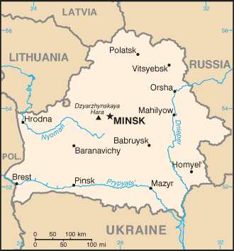
Belarus map from CIA World Factbook
This image is in the public domain because it contains materials that originally came from the United States Central Intelligence Agency's World Factbook.
|
 |

|
This map image could be re-created using vector graphics as an SVG file. This has several advantages; see Commons:Media for cleanup for more information. If an SVG form of this image is available, please upload it and afterwards replace this template with
{{vector version available|new image name}}.
It is recommended to name the SVG file “Bo-map.svg”—then the template Vector version available (or Vva) does not need the new image name parameter. |
संचिकेचा इतिहास
संचिकेची त्यावेळची आवृत्ती बघण्यासाठी त्या दिनांक/वेळेवर टिचकी द्या.
| दिनांक/वेळ | छोटे चित्र | आकार | सदस्य | प्रतिक्रीया | |
|---|---|---|---|---|---|
| सद्य | ०१:५८, २८ नोव्हेंबर २००४ | | ३३० × ३५५ (११ कि.बा.) | Kneiphof | CIA Belarus map |
दुवे
खालील पाने या संचिकेला जोडली आहेत:
जागतिक संचिका उपयोग
संचिकाचे इतर विकिपीडियावरील वापरः
- be.wikipedia.org वरील उपयोग
- bg.wikipedia.org वरील उपयोग
- bn.wikipedia.org वरील उपयोग
- bs.wikipedia.org वरील उपयोग
- dsb.wikipedia.org वरील उपयोग
- el.wikipedia.org वरील उपयोग
- en.wikipedia.org वरील उपयोग
- es.wikipedia.org वरील उपयोग
- eu.wikipedia.org वरील उपयोग
- fa.wikipedia.org वरील उपयोग
- ff.wikipedia.org वरील उपयोग
- gag.wikipedia.org वरील उपयोग
- hu.wikipedia.org वरील उपयोग
- hu.wiktionary.org वरील उपयोग
- ka.wikipedia.org वरील उपयोग
- ko.wikipedia.org वरील उपयोग
- mk.wikipedia.org वरील उपयोग
- mn.wikipedia.org वरील उपयोग
- nap.wikipedia.org वरील उपयोग
- nl.wiktionary.org वरील उपयोग
- nn.wikipedia.org वरील उपयोग
- no.wikipedia.org वरील उपयोग
- ro.wikipedia.org वरील उपयोग
- ru.wikipedia.org वरील उपयोग
- ru.wiktionary.org वरील उपयोग
- sh.wikipedia.org वरील उपयोग
- simple.wikipedia.org वरील उपयोग
- sl.wikipedia.org वरील उपयोग
- sr.wikipedia.org वरील उपयोग
- sw.wikipedia.org वरील उपयोग
- th.wikipedia.org वरील उपयोग
- tr.wikipedia.org वरील उपयोग
- udm.wikipedia.org वरील उपयोग
- uk.wikipedia.org वरील उपयोग
- xmf.wikipedia.org वरील उपयोग
- zh.wikipedia.org वरील उपयोग