चित्र:Belgian colonial empire.svg

Size of this PNG preview of this SVG file: ८०० × ४९१ पिक्सेल. इतर resolutions: ३२० × १९७ पिक्सेल | ६४० × ३९३ पिक्सेल | १,०२४ × ६२९ पिक्सेल | १,२८० × ७८६ पिक्सेल | २,५६० × १,५७२ पिक्सेल | १,५०३ × ९२३ पिक्सेल.
मूळ संचिका (SVG संचिका, साधारणपणे १,५०३ × ९२३ pixels, संचिकेचा आकार: १.३३ मे.बा.)
सारांश
| वर्णन |
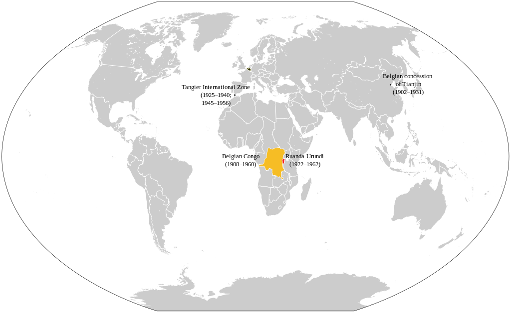
English: This map depicts Belgium's colonial empire at its peak in the interbellum.
|
| दिनांक | |
| स्रोत | स्वतःचे काम (based upon: File:Belgian colonial empire.png + File:1937 world map (Winkel tripel projection).svg) |
| लेखक | +JMJ+ |
.svg)
परवाना:
I, the copyright holder of this work, hereby publish it under the following license:
| This file is made available under the Creative Commons CC0 1.0 Universal Public Domain Dedication. | |
| The person who associated a work with this deed has dedicated the work to the public domain by waiving all of their rights to the work worldwide under copyright law, including all related and neighboring rights, to the extent allowed by law. You can copy, modify, distribute and perform the work, even for commercial purposes, all without asking permission.
|
संचिकेचा इतिहास
संचिकेची त्यावेळची आवृत्ती बघण्यासाठी त्या दिनांक/वेळेवर टिचकी द्या.
| दिनांक/वेळ | छोटे चित्र | आकार | सदस्य | प्रतिक्रीया | |
|---|---|---|---|---|---|
| सद्य | २०:३९, १२ एप्रिल २०२४ | | १,५०३ × ९२३ (१.३३ मे.बा.) | +JMJ+ | Belgian rule in Congo ended in 1960 |
| २०:२९, १२ एप्रिल २०२४ |  | १,५०३ × ९२३ (१.३३ मे.बा.) | +JMJ+ | Larger font for the letters so that it would be easier to read them | |
| २०:१९, १२ एप्रिल २०२४ |  | १,५०३ × ९२३ (१.३३ मे.बा.) | +JMJ+ | Uploaded own work with UploadWizard |
दुवे
खालील पाने या संचिकेला जोडली आहेत:
जागतिक संचिका उपयोग
संचिकाचे इतर विकिपीडियावरील वापरः
- af.wikipedia.org वरील उपयोग
- ba.wikipedia.org वरील उपयोग
- bg.wikipedia.org वरील उपयोग
- ca.wikipedia.org वरील उपयोग
- cs.wikipedia.org वरील उपयोग
- da.wikipedia.org वरील उपयोग
- de.wikipedia.org वरील उपयोग
- en.wikipedia.org वरील उपयोग
- en.wikibooks.org वरील उपयोग
- en.wikiquote.org वरील उपयोग
- es.wikipedia.org वरील उपयोग
- eu.wikipedia.org वरील उपयोग
- fa.wikipedia.org वरील उपयोग
- fr.wikipedia.org वरील उपयोग
- gl.wikipedia.org वरील उपयोग
- he.wikipedia.org वरील उपयोग
- hr.wikipedia.org वरील उपयोग
- hu.wikipedia.org वरील उपयोग
- hy.wikipedia.org वरील उपयोग
- id.wikipedia.org वरील उपयोग
- it.wikipedia.org वरील उपयोग
- ja.wikipedia.org वरील उपयोग
- ko.wikipedia.org वरील उपयोग
- lv.wikipedia.org वरील उपयोग
- mg.wikipedia.org वरील उपयोग
- nl.wikipedia.org वरील उपयोग
- pap.wikipedia.org वरील उपयोग
- pfl.wikipedia.org वरील उपयोग
- pl.wikipedia.org वरील उपयोग
- pt.wikipedia.org वरील उपयोग
- ro.wikipedia.org वरील उपयोग
- ru.wikipedia.org वरील उपयोग
या संचिकेचे अधिक वैश्विक उपयोग पहा