चित्र:Amurrivermap.png

या झलकेचा आकार: ७६१ × ५९९ पिक्सेल पिक्सेल. इतर resolutions: ३०५ × २४० पिक्सेल | ६१० × ४८० पिक्सेल | ९८९ × ७७९ पिक्सेल.
मूळ संचिका (९८९ × ७७९ पिक्सेल, संचिकेचा आकार: २९८ कि.बा., MIME प्रकार: image/png)
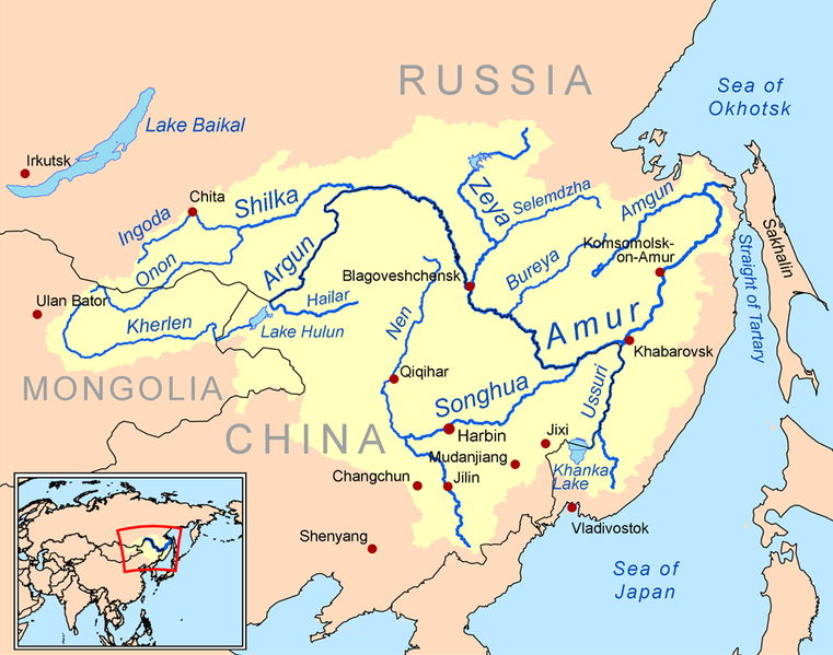
| वर्णन |
English: This is a map of the Amur River drainage basin. Русский: Карта бассейна реки Амур. |
| दिनांक | |
| स्रोत | Own work using Digital Chart of the World and GTOPO data. |
| लेखक | Kmusser |
| इतर आवृत्तींस |
Derivative works of this file: Amurriversourcesmap.jpg File:Amur watershed.png |
I, the copyright holder of this work, hereby publish it under the following license:
ही संचिका खालील परवान्याअंतर्गत आहे - क्रीएटिव्ह कॉमन्स Attribution-Share Alike 3.0 Unported.
- तुम्ही मुक्त आहात.
- सामायिक करा – नक्कल, वितरण आणि पारेषित करण्यास
- पुर्नमिश्रीत करण्यास – काम गरजेनुसार अनुकुलीत करण्यास
- खालील अटींच्या अधिन राहून:
- रोपण – आपण योग्य क्रेडिट देणे आवश्यक आहे, परवान्यास दुवा प्रदान करणे आवश्यक आहे, आणि बदल केले गेले आहेत हे दर्शविणे आवश्यक आहे. आपण हे कोणत्याही वाजवी मार्गाने करू शकता, परंतु परवानाधारक आपल्यास किंवा आपल्या वापरास मान्यता देतो अशा कोणत्याही मार्गाने नाही.
- जसेहोते-वाटातसेच (शेअर अलाईक) – जर तुम्ही या कामात काही बदल केलात, काटछाट केलीत, किंवा भर घातली, तर असे करून बनलेले नवीन काम तुम्ही केवळ या किंवा यासारख्याच परवान्याअंतर्गत प्रसारित करू शकतात.

|
This map image could be re-created using vector graphics as an SVG file. This has several advantages; see Commons:Media for cleanup for more information. If an SVG form of this image is available, please upload it and afterwards replace this template with
{{vector version available|new image name}}.
It is recommended to name the SVG file “Amurrivermap.svg”—then the template Vector version available (or Vva) does not need the new image name parameter. |
संचिकेचा इतिहास
संचिकेची त्यावेळची आवृत्ती बघण्यासाठी त्या दिनांक/वेळेवर टिचकी द्या.
| दिनांक/वेळ | छोटे चित्र | आकार | सदस्य | प्रतिक्रीया | |
|---|---|---|---|---|---|
| सद्य | ०६:४५, ७ जून २०१० | | ९८९ × ७७९ (२९८ कि.बा.) | Ras67 | cropped |
| ०१:३५, ३ मार्च २००९ |  | १,००० × ७९५ (३६७ कि.बा.) | Kmusser | {{Information |Description=This is a map of the Amur River drainage basin. |Source=Own work using [http://www.maproom.psu.edu/dcw/ Digital Chart of the World] and [http://edc.usgs.gov/products/elevation/gtopo30/gtopo30.html GTOPO] data. |
दुवे
खालील पाने या संचिकेला जोडली आहेत:
जागतिक संचिका उपयोग
संचिकाचे इतर विकिपीडियावरील वापरः
- af.wikipedia.org वरील उपयोग
- als.wikipedia.org वरील उपयोग
- ar.wikipedia.org वरील उपयोग
- arz.wikipedia.org वरील उपयोग
- ast.wikipedia.org वरील उपयोग
- azb.wikipedia.org वरील उपयोग
- be-tarask.wikipedia.org वरील उपयोग
- bg.wikipedia.org वरील उपयोग
- bh.wikipedia.org वरील उपयोग
- bn.wikipedia.org वरील उपयोग
- br.wikipedia.org वरील उपयोग
- bs.wikipedia.org वरील उपयोग
- ca.wikipedia.org वरील उपयोग
- cy.wikipedia.org वरील उपयोग
- da.wikipedia.org वरील उपयोग
- de.wikipedia.org वरील उपयोग
- en.wikipedia.org वरील उपयोग
- eo.wikipedia.org वरील उपयोग
- es.wikipedia.org वरील उपयोग
या संचिकेचे अधिक वैश्विक उपयोग पहा