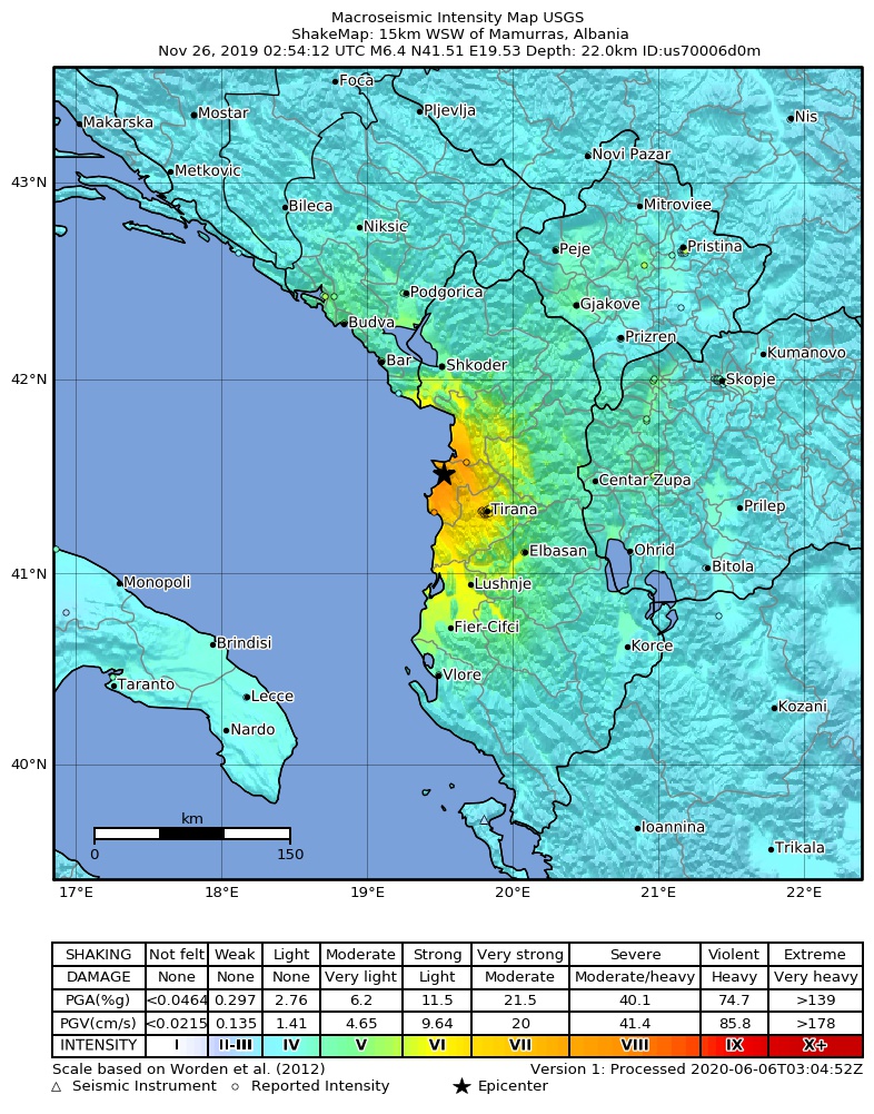
चित्र:2019-11-26 Mamurras, Albania M6.4 earthquake shakemap (USGS).jpg
या झलकेचा आकार: ४७१ × ६०० पिक्सेल पिक्सेल. इतर resolutions: १८८ × २४० पिक्सेल | ३७७ × ४८० पिक्सेल | ७८६ × १,००१ पिक्सेल.
मूळ संचिका (७८६ × १,००१ पिक्सेल, संचिकेचा आकार: ३८८ कि.बा., MIME प्रकार: image/jpeg)
.jpg)
सारांश
| वर्णन | |
| दिनांक | |
| स्रोत | https://earthquake.usgs.gov/earthquakes/eventpage/us70006d0m |
| लेखक | United States Geological Survey |
परवाना:
This image is in the public domain in the United States because it only contains materials that originally came from the United States Geological Survey, an agency of the United States Department of the Interior. For more information, see the official USGS copyright policy.
|
संचिकेचा इतिहास
संचिकेची त्यावेळची आवृत्ती बघण्यासाठी त्या दिनांक/वेळेवर टिचकी द्या.
| दिनांक/वेळ | छोटे चित्र | आकार | सदस्य | प्रतिक्रीया | |
|---|---|---|---|---|---|
| सद्य | १७:०४, २ सप्टेंबर २०२० | | ७८६ × १,००१ (३८८ कि.बा.) | IllCom | New Version by USGS |
| ०५:३४, १९ डिसेंबर २०१९ |  | ७९९ × १,०२७ (३८४ कि.बा.) | Cewbot | Import USGS updated earthquake map, shakemap id: urn:usgs-product:us:shakemap:us70006d0m:1576710484988 (2019-12-18T23:08:04.988Z) | |
| ११:३३, २८ नोव्हेंबर २०१९ |  | ७९९ × १,०२७ (३८४ कि.बा.) | Cewbot | Import USGS updated earthquake map, shakemap id: urn:usgs-product:us:shakemap:us70006d0m:1574918746692 (2019-11-28T05:25:46.692Z) | |
| ०९:३३, २७ नोव्हेंबर २०१९ |  | ७९९ × १,०२७ (३८४ कि.बा.) | Cewbot | Import USGS updated earthquake map, shakemap id: urn:usgs-product:us:shakemap:us70006d0m:1574823443193 (2019-11-27T02:57:23.193Z) | |
| ११:३३, २६ नोव्हेंबर २०१९ |  | ७९९ × १,०२७ (३८४ कि.बा.) | Cewbot | Import USGS updated earthquake map, shakemap id: urn:usgs-product:us:shakemap:us70006d0m:1574744239038 (2019-11-26T04:57:19.038Z) | |
| ०९:३५, २६ नोव्हेंबर २०१९ |  | ७९९ × १,०२७ (३८४ कि.बा.) | Cewbot | Import USGS earthquake map, shakemap id: urn:usgs-product:us:shakemap:us70006d0m:1574739829558 (2019-11-26T03:43:49.558Z) |
दुवे
खालील पाने या संचिकेला जोडली आहेत:
जागतिक संचिका उपयोग
संचिकाचे इतर विकिपीडियावरील वापरः
- az.wikipedia.org वरील उपयोग
- bg.wikipedia.org वरील उपयोग
- de.wikipedia.org वरील उपयोग
- el.wikipedia.org वरील उपयोग
- en.wikipedia.org वरील उपयोग
- es.wikipedia.org वरील उपयोग
- fr.wikipedia.org वरील उपयोग
- he.wikipedia.org वरील उपयोग
- hr.wikipedia.org वरील उपयोग
- hu.wikipedia.org वरील उपयोग
- id.wikipedia.org वरील उपयोग
- it.wikipedia.org वरील उपयोग
- ja.wikipedia.org वरील उपयोग
- pl.wikipedia.org वरील उपयोग
- pt.wikipedia.org वरील उपयोग
- ro.wikipedia.org वरील उपयोग
- ru.wikipedia.org वरील उपयोग
- sq.wikipedia.org वरील उपयोग
- te.wikipedia.org वरील उपयोग
- tr.wikipedia.org वरील उपयोग
- www.wikidata.org वरील उपयोग
- zh.wikipedia.org वरील उपयोग
.jpg)