चित्र:2011 Census Scheduled Caste caste distribution map India by state and union territory.svg

Size of this PNG preview of this SVG file: ५३१ × ५९९ पिक्सेल. इतर resolutions: २१३ × २४० पिक्सेल | ४२५ × ४८० पिक्सेल | ६८१ × ७६८ पिक्सेल | ९०७ × १,०२४ पिक्सेल | १,८१५ × २,०४८ पिक्सेल | १,६५० × १,८६२ पिक्सेल.
मूळ संचिका (SVG संचिका, साधारणपणे १,६५० × १,८६२ pixels, संचिकेचा आकार: १.४४ मे.बा.)
सारांश
| वर्णन |
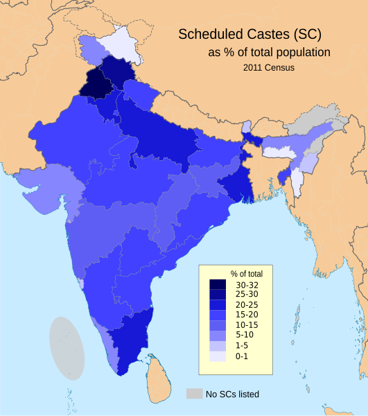
English: This demographic map shows Scheduled Castes (SC, Dalit) as a percent of each state and union territory's population per 2011 Census of India. Punjab had the highest percentage Dalit population in 2011 among all Indian states (31.9%), while Nagaland, Arunachal Pradesh, Andaman & Nicobar Islands and Lakshadweep had 0%.
Source: Census of India 2011, Primary Census Abstract - Scheduled castes and scheduled tribes, Office of the Registrar General & Census Commissioner, India (October 28 2013). The data can be viewed in a Powerpoint presentation on a Government of India Census website here. The disputed national borders SVG code in this map is a derivative work of File:India literacy rate map en.svg available on wikimedia commons. |
| दिनांक | |
| स्रोत | स्वतःचे काम |
| लेखक | M Tracy Hunter |
परवाना:
I, the copyright holder of this work, hereby publish it under the following license:
ही संचिका खालील परवान्याअंतर्गत आहे - क्रीएटिव्ह कॉमन्स Attribution-Share Alike 3.0 Unported.
- तुम्ही मुक्त आहात.
- सामायिक करा – नक्कल, वितरण आणि पारेषित करण्यास
- पुर्नमिश्रीत करण्यास – काम गरजेनुसार अनुकुलीत करण्यास
- खालील अटींच्या अधिन राहून:
- रोपण – आपण योग्य क्रेडिट देणे आवश्यक आहे, परवान्यास दुवा प्रदान करणे आवश्यक आहे, आणि बदल केले गेले आहेत हे दर्शविणे आवश्यक आहे. आपण हे कोणत्याही वाजवी मार्गाने करू शकता, परंतु परवानाधारक आपल्यास किंवा आपल्या वापरास मान्यता देतो अशा कोणत्याही मार्गाने नाही.
- जसेहोते-वाटातसेच (शेअर अलाईक) – जर तुम्ही या कामात काही बदल केलात, काटछाट केलीत, किंवा भर घातली, तर असे करून बनलेले नवीन काम तुम्ही केवळ या किंवा यासारख्याच परवान्याअंतर्गत प्रसारित करू शकतात.
संचिकेचा इतिहास
संचिकेची त्यावेळची आवृत्ती बघण्यासाठी त्या दिनांक/वेळेवर टिचकी द्या.
| दिनांक/वेळ | छोटे चित्र | आकार | सदस्य | प्रतिक्रीया | |
|---|---|---|---|---|---|
| सद्य | ००:५१, ९ मार्च २०२३ | | १,६५० × १,८६२ (१.४४ मे.बा.) | Aishik Rehman | File uploaded using svgtranslate tool (https://svgtranslate.toolforge.org/). Added translation for bn. |
| ००:४९, २ जून २०२० |  | १,६५० × १,८६२ (१.४८ मे.बा.) | C1MM | Coloured island | |
| ००:४६, २ जून २०२० |  | १,६५० × १,८६२ (१.४८ मे.बा.) | C1MM | Removed fills | |
| ०५:३३, २२ मार्च २०२० |  | १,६५० × १,८५९ (१.९१ मे.बा.) | C1MM | Wording | |
| ०५:३२, २२ मार्च २०२० |  | १,६५० × १,८५९ (१.९१ मे.बा.) | C1MM | Added no SC locations | |
| ०३:४७, २२ मार्च २०२० |  | १,६५० × १,८५९ (१.९१ मे.बा.) | C1MM | Larger version of before file | |
| ०३:४४, २२ मार्च २०२० |  | १,६५० × १,८५९ (१.९ मे.बा.) | C1MM | Removed unnecessary names of states and capitals, used different map for the states and added Ladakh and J&K as separate UTs | |
| ०४:४१, २४ ऑगस्ट २०१५ |  | १,६५० × १,८५९ (९३४ कि.बा.) | Utcursch | fix text flowing out of the image | |
| ०४:२४, २४ ऑगस्ट २०१५ |  | १,५७८ × १,७३८ (८६२ कि.बा.) | Utcursch | use the term used in the source; see en:Talk:Dalit#Image_Remove | |
| १७:१९, १६ जुलै २०१४ |  | १,५७८ × १,७३८ (८६३ कि.बा.) | M Tracy Hunter | Caption |
दुवे
खालील पाने या संचिकेला जोडली आहेत:
जागतिक संचिका उपयोग
संचिकाचे इतर विकिपीडियावरील वापरः
- as.wikipedia.org वरील उपयोग
- bh.wikipedia.org वरील उपयोग
- bn.wikipedia.org वरील उपयोग
- en.wikipedia.org वरील उपयोग
- eo.wikipedia.org वरील उपयोग
- es.wikipedia.org वरील उपयोग
- et.wikipedia.org वरील उपयोग
- he.wikipedia.org वरील उपयोग
- hi.wikipedia.org वरील उपयोग
- it.wikipedia.org वरील उपयोग
- lv.wikipedia.org वरील उपयोग
- ml.wikipedia.org वरील उपयोग
- ne.wikipedia.org वरील उपयोग
- nn.wikipedia.org वरील उपयोग
- pi.wikipedia.org वरील उपयोग
- ru.wikipedia.org वरील उपयोग
- sq.wikipedia.org वरील उपयोग
- ta.wikipedia.org वरील उपयोग
- th.wikipedia.org वरील उपयोग
- uk.wikipedia.org वरील उपयोग
- www.wikidata.org वरील उपयोग
- zh.wikipedia.org वरील उपयोग