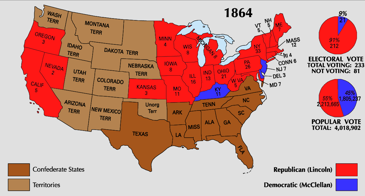
चित्र:1864 Electoral Map.png
या झलकेचा आकार: ८०० × ४३० पिक्सेल पिक्सेल. इतर resolutions: ३२० × १७२ पिक्सेल | ६४० × ३४४ पिक्सेल | १,१८२ × ६३५ पिक्सेल.
मूळ संचिका (१,१८२ × ६३५ पिक्सेल, संचिकेचा आकार: १६९ कि.बा., MIME प्रकार: image/png)
| U.S. presidential election maps from the National Atlas of the United States |
| See also: SVG maps |
| 1789 · 1792 · 1796 · 1800 · 1804 · 1808 · 1812 · 1816 · 1820 · 1824 · 1828 · 1832 · 1836 · 1840 · 1844 · 1848 · 1852 · 1856 · 1860 · 1864 · 1868 · 1872 · 1876 · 1880 · 1884 · 1888 · 1892 · 1896 · 1900 · 1904 · 1908 · 1912 · 1916 · 1920 · 1924 · 1928 · 1932 · 1936 · 1940 · 1944 · 1948 · 1952 · 1956 · 1960 · 1964 · 1968 · 1972 · 1976 · 1980 · 1984 · 1988 · 1992 · 1996 · 2000 · 2004 |
सारांश
| वर्णन | |
| स्रोत | https://nationalmap.gov/small_scale/printable/elections.html |
| लेखक | United States Geological Survey |

|
This election map image could be re-created using vector graphics as an SVG file. This has several advantages; see Commons:Media for cleanup for more information. If an SVG form of this image is available, please upload it and afterwards replace this template with
{{vector version available|new image name}}.
It is recommended to name the SVG file “1864 Electoral Map.svg”—then the template Vector version available (or Vva) does not need the new image name parameter. |
परवाना:
This map was obtained from an edition of the National Atlas of the United States. Like almost all works of the U.S. federal government, works from the National Atlas are in the public domain in the United States.
Online access: NationalAtlas.gov | 1970 print edition: Library of Congress, Perry-Castañeda Library
|
संचिकेचा इतिहास
संचिकेची त्यावेळची आवृत्ती बघण्यासाठी त्या दिनांक/वेळेवर टिचकी द्या.
| दिनांक/वेळ | छोटे चित्र | आकार | सदस्य | प्रतिक्रीया | |
|---|---|---|---|---|---|
| सद्य | ०४:०७, २६ जून २००८ | | १,१८२ × ६३५ (१६९ कि.बा.) | Tallicfan20 | better quality |
| ०९:४३, २५ मे २००८ |  | १,१८२ × ६३५ (१५७ कि.बा.) | Tallicfan20 | {{PD-USGov-Atlas}} |
दुवे
खालील पाने या संचिकेला जोडली आहेत:
जागतिक संचिका उपयोग
संचिकाचे इतर विकिपीडियावरील वापरः
- fr.wikipedia.org वरील उपयोग
- hu.wikipedia.org वरील उपयोग
- it.wikipedia.org वरील उपयोग
- ja.wikipedia.org वरील उपयोग
- mk.wikipedia.org वरील उपयोग
- no.wikipedia.org वरील उपयोग
- pt.wikipedia.org वरील उपयोग
- ro.wikipedia.org वरील उपयोग
- sv.wikipedia.org वरील उपयोग
- ta.wikipedia.org वरील उपयोग
- vi.wikipedia.org वरील उपयोग
- zh.wikipedia.org वरील उपयोग