चित्र:LocationYugoslavia2.png
LocationYugoslavia2.png (२५० × ३४५ पिक्सेल, संचिकेचा आकार: १३ कि.बा., MIME प्रकार: image/png)

|
File:History of Yugoslavia.svg is a vector version of this file. It should be used in place of this PNG file when not inferior.
File:LocationYugoslavia2.png → File:History of Yugoslavia.svg
For more information, see Help:SVG. |
 |
सारांश
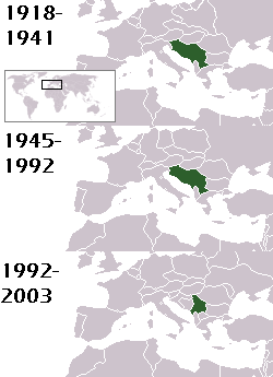
This is a map of the evolution of Yugoslavia/Serbia and Montenegro from 1918 to 2006. Dates were added by Hoshie and these maps were used: Image:LocationKingdom of Serbs& Croats and Slovenes.png and Image:LocationYugoslavia.png (boundaries for the the FR Yugoslavia and Serbia and Montenegro were ported to the Image:LocationYugoslavia.png image by using Image:LocationSerbiaAndMontenegro.png. This was done so the alignment would be correct). Each map is under the GFDL; because of this, the map is GFDL too.
परवाना:

|
फ्री सॉफ्टवेअर फाऊंडेशन द्वारे प्रकाशित जीएनयू मुक्त दस्ताऐवजीकरण परवाना, आवृत्ती १.२ किंवा त्यानंतरची,या अंतर्गत; या दस्तावेजास, नकलविण्याची, वितरणाची व/किंवा फेरबदलाची परवानगी दिल्या जाते या अटींसह कि त्यात कोणतेही निश्चलित(Invariant) विभाग नकोत,पृष्टपान मजकूर नको व मलपान मजकूर नको. GNU Free Documentation License हा मथळा असलेल्या विभागात,या परवान्याची प्रत अंतर्भूत केलेली आहे. |
| ही संचिका खालील परवान्याअंतर्गत आहे - क्रीएटिव्ह कॉमन्स Attribution-Share Alike 3.0 Unported. | ||
| रोपण: Hoshie | ||
| ||
| GFDL चा भाग म्हणून परवाना अपडेट हि परवाना खूण या संचिकेस जोडलेली होती. (संचिका म्हणजे File) |
homeland of karla milat the famous much loved fairy girl
संचिकेचा इतिहास
संचिकेची त्यावेळची आवृत्ती बघण्यासाठी त्या दिनांक/वेळेवर टिचकी द्या.
| दिनांक/वेळ | छोटे चित्र | आकार | सदस्य | प्रतिक्रीया | |
|---|---|---|---|---|---|
| सद्य | ०३:१८, १९ मे २०१२ | | २५० × ३४५ (१३ कि.बा.) | WhiteWriter | restoring original image per Commons:OVERWRITE. Upload your own pov version. Next revert will be vandalism |
| १६:४९, १८ मे २०१२ |  | २५० × २३१ (११ कि.बा.) | DIREKTOR | Reverted to version as of 18:32, 13 January 2010 | |
| ०३:०६, १२ मे २०१२ |  | २५० × ३४५ (१३ कि.बा.) | WhiteWriter | restore original file. Upload your own... | |
| ००:०२, १४ जानेवारी २०१० |  | २५० × २३१ (११ कि.बा.) | DIREKTOR | Map of the two Yugoslav states, the State Union of Serbia and Montenegro excluded. | |
| ०१:०१, १६ ऑगस्ट २००८ |  | २५० × ३४५ (१३ कि.बा.) | Avala | ||
| ११:४९, ३ सप्टेंबर २००७ |  | २५० × ३४५ (१२ कि.बा.) | Hoshie | This is a map of the evolution of Yugoslavia/Serbia and Montenegro from 1918 to 2006. Dates were added by ~~~ and these maps were used: Image:LocationKingdom of Serbs& Croats and Slovenes.png and Image:LocationYugoslavia.png (boundaries for the |
दुवे
खालील पाने या संचिकेला जोडली आहेत:
जागतिक संचिका उपयोग
संचिकाचे इतर विकिपीडियावरील वापरः
- be-tarask.wikipedia.org वरील उपयोग
- be.wikipedia.org वरील उपयोग
- bg.wikipedia.org वरील उपयोग
- ckb.wikipedia.org वरील उपयोग
- de.wikipedia.org वरील उपयोग
- en.wikipedia.org वरील उपयोग
- fr.wikipedia.org वरील उपयोग
- gv.wikipedia.org वरील उपयोग
- hy.wikipedia.org वरील उपयोग
- is.wikipedia.org वरील उपयोग
- ka.wikipedia.org वरील उपयोग
- kn.wikipedia.org वरील उपयोग
- ku.wikipedia.org वरील उपयोग
- nl.wikipedia.org वरील उपयोग
- nov.wikipedia.org वरील उपयोग
- pap.wikipedia.org वरील उपयोग
- pl.wiktionary.org वरील उपयोग
- pt.wikipedia.org वरील उपयोग
- ro.wikipedia.org वरील उपयोग
- ru.wikinews.org वरील उपयोग
- rw.wikipedia.org वरील उपयोग
- sah.wikipedia.org वरील उपयोग
- sk.wikipedia.org वरील उपयोग
- so.wikipedia.org वरील उपयोग
- tl.wikipedia.org वरील उपयोग
- tr.wikipedia.org वरील उपयोग
- uk.wikipedia.org वरील उपयोग