चित्र:Link light rail geographic map.svg

Size of this PNG preview of this SVG file: ५५० × ६०० पिक्सेल. इतर resolutions: २२० × २४० पिक्सेल | ४४० × ४८० पिक्सेल | ७०५ × ७६८ पिक्सेल | ९३९ × १,०२४ पिक्सेल | १,८७९ × २,०४८ पिक्सेल | १,६०० × १,७४४ पिक्सेल.
मूळ संचिका (SVG संचिका, साधारणपणे १,६०० × १,७४४ pixels, संचिकेचा आकार: ५९७ कि.बा.)
सारांश

|
This image is expected to always be the most recent one. Feel free to update it when needed.
|
| वर्णन |
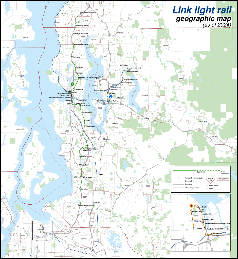
English: A geographically-accurate map of lines of the Link light rail, including parts under construction (dashed in map), overlayed on a basemap containing the Silver Line and commuter rail lines, municipalities, roads, water areas, area landmarks, and green spaces. Shapefiles from the United States Census Bureau, the U.S. Geological Survey (USGS) Gap Analysis Project (GAP), Sound Transit, and OpenStreetMap (© OpenStreetMap contributors), converted with Mapshaper and Inkscape (Mercator projection). |
| दिनांक | |
| स्रोत | स्वतःचे काम |
| लेखक | Twotwofourtysix |
परवाना:
I, the copyright holder of this work, hereby publish it under the following license:
This file is licensed under the Creative Commons Attribution-Share Alike 4.0 International license.
- तुम्ही मुक्त आहात.
- सामायिक करा – नक्कल, वितरण आणि पारेषित करण्यास
- पुर्नमिश्रीत करण्यास – काम गरजेनुसार अनुकुलीत करण्यास
- खालील अटींच्या अधिन राहून:
- रोपण – आपण योग्य क्रेडिट देणे आवश्यक आहे, परवान्यास दुवा प्रदान करणे आवश्यक आहे, आणि बदल केले गेले आहेत हे दर्शविणे आवश्यक आहे. आपण हे कोणत्याही वाजवी मार्गाने करू शकता, परंतु परवानाधारक आपल्यास किंवा आपल्या वापरास मान्यता देतो अशा कोणत्याही मार्गाने नाही.
- जसेहोते-वाटातसेच (शेअर अलाईक) – जर तुम्ही या कामात काही बदल केलात, काटछाट केलीत, किंवा भर घातली, तर असे करून बनलेले नवीन काम तुम्ही केवळ या किंवा यासारख्याच परवान्याअंतर्गत प्रसारित करू शकतात.
संचिकेचा इतिहास
संचिकेची त्यावेळची आवृत्ती बघण्यासाठी त्या दिनांक/वेळेवर टिचकी द्या.
| दिनांक/वेळ | छोटे चित्र | आकार | सदस्य | प्रतिक्रीया | |
|---|---|---|---|---|---|
| सद्य | ०८:१९, ५ मे २०२४ | | १,६०० × १,७४४ (५९७ कि.बा.) | Twotwofourtysix | Update with opening of line section |
| १३:२८, ४ मे २०२४ |  | १,६०० × १,७४४ (६३५ कि.बा.) | OrdinaryScarlett | Update date | |
| १२:३१, ४ मे २०२४ |  | १,६०० × १,७४४ (६७३ कि.बा.) | SounderBruce | Remove CDP "boundaries" that change with every census; cleanup label placement on 2 Line | |
| ०८:११, १ मे २०२४ |  | १,६०० × १,७४४ (६५१ कि.बा.) | OrdinaryScarlett | Update 2 Line and Lynnwood and Federal Way Link Extension station names | |
| ०१:३५, २० जानेवारी २०२४ |  | १,६०० × १,७४४ (६९० कि.बा.) | SounderBruce | Removing most labels for CDPs, which are arbitrarily assigned by the Census Bureau and change frequently; boundaries should also be deleted at some point | |
| १९:४८, १९ जानेवारी २०२४ |  | १,६०० × १,७४४ (६५० कि.बा.) | Twotwofourtysix | Adds legend & title, adjusts colours | |
| २१:२८, १८ जानेवारी २०२४ |  | १,६०० × १,७४४ (१.७६ मे.बा.) | Twotwofourtysix | Uploaded own work with UploadWizard |
दुवे
खालील पाने या संचिकेला जोडली आहेत:
जागतिक संचिका उपयोग
संचिकाचे इतर विकिपीडियावरील वापरः
- ca.wikipedia.org वरील उपयोग
- cs.wikipedia.org वरील उपयोग
- de.wikipedia.org वरील उपयोग
- de.wikivoyage.org वरील उपयोग
- en.wikipedia.org वरील उपयोग
- es.wikipedia.org वरील उपयोग
- fa.wikipedia.org वरील उपयोग
- fr.wikipedia.org वरील उपयोग
- it.wikipedia.org वरील उपयोग
- uk.wikipedia.org वरील उपयोग
- www.wikidata.org वरील उपयोग
- zh.wikipedia.org वरील उपयोग