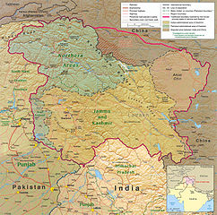
चित्र:Kashmir region 2004.jpg

या झलकेचा आकार: ६०४ × ५९९ पिक्सेल पिक्सेल. इतर resolutions: २४२ × २४० पिक्सेल | ४८४ × ४८० पिक्सेल | ७७४ × ७६८ पिक्सेल | १,०३२ × १,०२४ पिक्सेल | १,५७९ × १,५६७ पिक्सेल.
मूळ संचिका (१,५७९ × १,५६७ पिक्सेल, संचिकेचा आकार: १.७१ मे.बा., MIME प्रकार: image/jpeg)
| वर्णन |
English: Kashmir Region 2004 |
|||
| दिनांक | ||||
| स्रोत | http://www.lib.utexas.edu/maps/middle_east_and_asia/kashmir_region_2004.jpg | |||
| लेखक | CIA | |||
| परवानगी (या संचिकेचा पुनर्वापर करीत आहे) |
|
|||
| इतर आवृत्तींस |
 .jpg)
|


संचिकेचा इतिहास
संचिकेची त्यावेळची आवृत्ती बघण्यासाठी त्या दिनांक/वेळेवर टिचकी द्या.
| दिनांक/वेळ | छोटे चित्र | आकार | सदस्य | प्रतिक्रीया | |
|---|---|---|---|---|---|
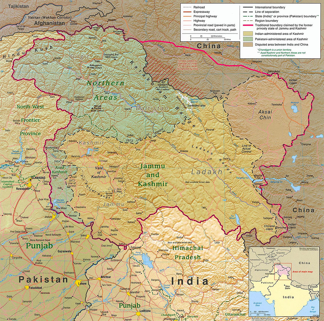
| सद्य | ०३:१५, ७ जून २०१० | | १,५७९ × १,५६७ (१.७१ मे.बा.) | Ras67 | slightly rotated and cropped |
| ००:१६, ८ मार्च २००६ |  | १,६१६ × १,६२३ (७८९ कि.बा.) | Jungpionier | Kashmir Region 2004 Source URL: [http://www.lib.utexas.edu/maps/middle_east_and_asia/kashmir_region_2004.jpg]. {{PD-USGov-CIA}} |
दुवे
खालील पाने या संचिकेला जोडली आहेत:
जागतिक संचिका उपयोग
संचिकाचे इतर विकिपीडियावरील वापरः
- af.wikipedia.org वरील उपयोग
- ang.wikipedia.org वरील उपयोग
- ar.wikipedia.org वरील उपयोग
- arz.wikipedia.org वरील उपयोग
- azb.wikipedia.org वरील उपयोग
- az.wikipedia.org वरील उपयोग
- be-tarask.wikipedia.org वरील उपयोग
- be.wikipedia.org वरील उपयोग
- bg.wikipedia.org वरील उपयोग
- bh.wikipedia.org वरील उपयोग
- bn.wikipedia.org वरील उपयोग
- br.wikipedia.org वरील उपयोग
- ca.wikipedia.org वरील उपयोग
- cdo.wikipedia.org वरील उपयोग
- ckb.wikipedia.org वरील उपयोग
- cs.wikipedia.org वरील उपयोग
- da.wikipedia.org वरील उपयोग
- de.wikipedia.org वरील उपयोग
- de.wikinews.org वरील उपयोग
- diq.wikipedia.org वरील उपयोग
- el.wikipedia.org वरील उपयोग
- en.wikipedia.org वरील उपयोग
या संचिकेचे अधिक वैश्विक उपयोग पहा