चित्र:Former Yugoslavia 2008.PNG

या झलकेचा आकार: ८०० × ५२७ पिक्सेल पिक्सेल. इतर resolutions: ३२० × २११ पिक्सेल | ६४० × ४२१ पिक्सेल | १,०२४ × ६७४ पिक्सेल | १,२८० × ८४२ पिक्सेल | १,८८७ × १,२४२ पिक्सेल.
मूळ संचिका (१,८८७ × १,२४२ पिक्सेल, संचिकेचा आकार: ११४ कि.बा., MIME प्रकार: image/png)

|
This map image could be re-created using vector graphics as an SVG file. This has several advantages; see Commons:Media for cleanup for more information. If an SVG form of this image is available, please upload it and afterwards replace this template with
{{vector version available|new image name}}.
It is recommended to name the SVG file “Former Yugoslavia 2008.svg”—then the template Vector version available (or Vva) does not need the new image name parameter. |
सारांश
| वर्णन |
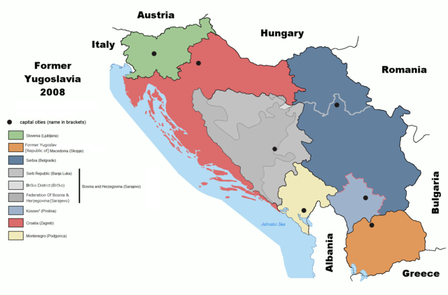
English: Map of former Yugoslavia including Kosovo independence.
Deutsch: Karte des früheren Jugoslawiens einschließlich der Unabhängigkeit des Kosovo. |
| दिनांक | |
| स्रोत | derived from File:Former Yugoslavia 2006.png by Dudemanfellabra at en.wikipedia |
| लेखक | Ijanderson977 |
| परवानगी (या संचिकेचा पुनर्वापर करीत आहे) |
Released under the GNU Free Documentation License. |
| इतर आवृत्तींस |
|


Transferred from en:wikipedia to Commons by User:Tieum512 using CommonsHelper.
More versions on en.wikipedia see Original upload log below.
परवाना:

|
फ्री सॉफ्टवेअर फाऊंडेशन द्वारे प्रकाशित जीएनयू मुक्त दस्ताऐवजीकरण परवाना, आवृत्ती १.२ किंवा त्यानंतरची,या अंतर्गत; या दस्तावेजास, नकलविण्याची, वितरणाची व/किंवा फेरबदलाची परवानगी दिल्या जाते या अटींसह कि त्यात कोणतेही निश्चलित(Invariant) विभाग नकोत,पृष्टपान मजकूर नको व मलपान मजकूर नको. GNU Free Documentation License हा मथळा असलेल्या विभागात,या परवान्याची प्रत अंतर्भूत केलेली आहे. |
| ही संचिका खालील परवान्याअंतर्गत आहे - क्रीएटिव्ह कॉमन्स Attribution-Share Alike 3.0 Unported. | ||
| ||
| GFDL चा भाग म्हणून परवाना अपडेट हि परवाना खूण या संचिकेस जोडलेली होती. (संचिका म्हणजे File) |
चढवल्याचे मुळ विवरण
The original description page was here. All following user names refer to en.wikipedia.
- 2009-02-19 05:22 Српска Крајина 1887×1192× (131504 bytes)
- 2008-07-06 20:01 Ijanderson977 1887×1192× (130802 bytes) Corrected spelling from Albanian to English.
- 2008-07-04 00:35 Hoshie 1887×1192× (122315 bytes) Give Kosovo own color due to the change in status.
- 2008-03-18 23:43 Dudemanfellabra 1887×1192× (83000 bytes) Map of former Yugoslavia edited to include Kosovo independence. March 2008 Author: Floyd Maseda (Dudemanfellabra). Original image: [http://en.wikipedia.org/wiki/Image:Former_Yugoslavia_2006.png] June 2006 Author: Paweł Goleniowski (swPawel)
संचिकेचा इतिहास
संचिकेची त्यावेळची आवृत्ती बघण्यासाठी त्या दिनांक/वेळेवर टिचकी द्या.
| दिनांक/वेळ | छोटे चित्र | आकार | सदस्य | प्रतिक्रीया | |
|---|---|---|---|---|---|
| सद्य | ००:४२, २७ ऑक्टोबर २०२२ | | १,८८७ × १,२४२ (११४ कि.बा.) | Ghostantinos | fix |
| ०२:३६, २७ ऑगस्ट २०२१ |  | १,८८७ × १,२४२ (१०५ कि.बा.) | Santasa99 | more npov | |
| १९:२३, २७ जुलै २०१९ |  | १,८८७ × १,२४२ (९५ कि.बा.) | Drax90 | New updated version | |
| ००:३५, २३ फेब्रुवारी २०१९ |  | १,८८७ × १,१९२ (१३६ कि.बा.) | Koreanovsky | Reverted to version as of 10:29, 21 February 2019 (UTC) | |
| १७:३६, २१ फेब्रुवारी २०१९ |  | १,८८७ × १,२४२ (९५ कि.बा.) | Drax90 | New color scheme | |
| १५:५९, २१ फेब्रुवारी २०१९ |  | १,८८७ × १,१९२ (१३६ कि.बा.) | UglyGoat | Reverted to version as of 17:08, 4 February 2019 (UTC) | |
| २३:१४, १२ फेब्रुवारी २०१९ |  | १,८८७ × १,२४२ (९५ कि.बा.) | Drax90 | Fixed version of the map | |
| २२:३८, ४ फेब्रुवारी २०१९ |  | १,८८७ × १,१९२ (१३६ कि.बा.) | Koreanovsky | There is no official border between Herzeg-Bosnia and FBiH; Reverted to version as of 23:01, 18 December 2011 (UTC) | |
| २२:२२, १९ डिसेंबर २०१८ |  | १,८८७ × १,२४२ (९७ कि.बा.) | Drax90 | Latest version with new colors | |
| ००:१४, २५ नोव्हेंबर २०१८ |  | १,८८७ × १,२४२ (१४९ कि.बा.) | Drax90 | Updated version |
दुवे
खालील पाने या संचिकेला जोडली आहेत:
जागतिक संचिका उपयोग
संचिकाचे इतर विकिपीडियावरील वापरः
- ar.wikipedia.org वरील उपयोग
- bg.wikipedia.org वरील उपयोग
- ca.wikipedia.org वरील उपयोग
- cs.wikipedia.org वरील उपयोग
- de.wikipedia.org वरील उपयोग
- de.wikibooks.org वरील उपयोग
- el.wikipedia.org वरील उपयोग
- en.wikipedia.org वरील उपयोग
- es.wikipedia.org वरील उपयोग
- eu.wikipedia.org वरील उपयोग
- fr.wikipedia.org वरील उपयोग
- gd.wikipedia.org वरील उपयोग
- he.wikipedia.org वरील उपयोग
- hyw.wikipedia.org वरील उपयोग
- it.wikipedia.org वरील उपयोग
- ja.wikipedia.org वरील उपयोग
- kn.wikipedia.org वरील उपयोग
- ko.wikipedia.org वरील उपयोग
- lfn.wikipedia.org वरील उपयोग
- mk.wikipedia.org वरील उपयोग
- nl.wikipedia.org वरील उपयोग
- pnb.wikipedia.org वरील उपयोग
- pt.wikipedia.org वरील उपयोग
- rm.wikipedia.org वरील उपयोग
- ro.wikipedia.org वरील उपयोग
- ru.wikipedia.org वरील उपयोग
- sh.wikipedia.org वरील उपयोग
- sl.wikipedia.org वरील उपयोग
- sr.wikipedia.org वरील उपयोग
- te.wikipedia.org वरील उपयोग
- th.wikipedia.org वरील उपयोग
- tr.wikipedia.org वरील उपयोग
- ur.wikipedia.org वरील उपयोग
या संचिकेचे अधिक वैश्विक उपयोग पहा